Exploring the Fitz Roy region

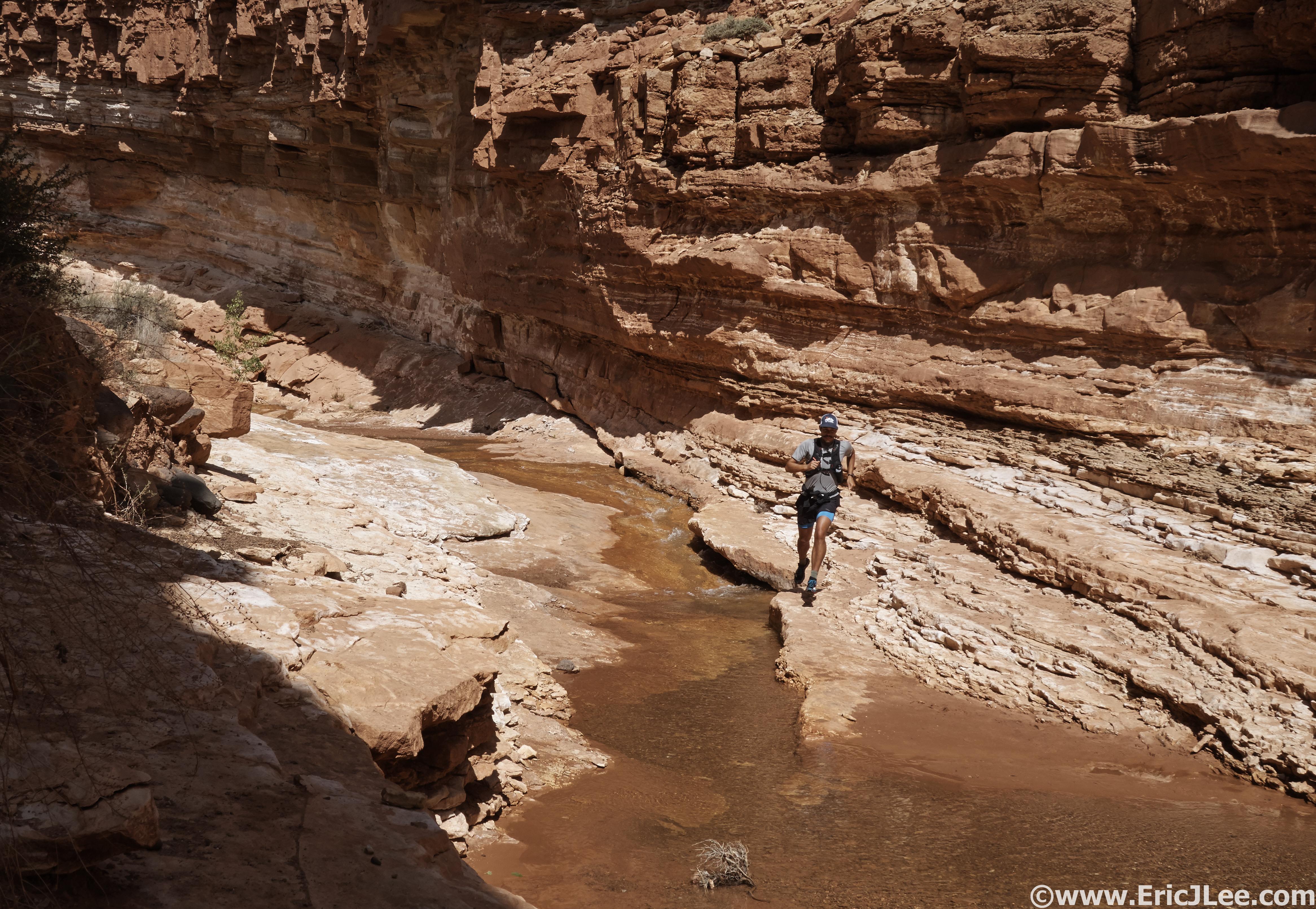
20 years ago El Chalten didn’t exist, merely a guard shack in a pristine mountain valley with Fitz Roy looming overhead. Today the quaint little town is the self appointed backpackers capital of Argentina, and rightfully so. Radiating from town are a network of trails that access some of the most spectacular scenery anywhere in the world. Incredible peaks, crystal blue lakes, immense glaciers and lush green valleys abound. The one problem, this town and it’s visitors are growing faster than the infrastructure. The few groceries in town have an incredibly limited selection, fruits and vegetables of barely edible quality, the one atm is often empty for a week at a time and prices are some of the highest you’ll find anywhere in Argentina. But it’s a place worth dirtbagging it and spending quite a bit of time.

Sunset over El Chalten from the edge of town, not too shabby.

I decided to setup shop at Kaiken hostel, a nice little house with 14 beds, a small living room and kitchen. It felt more like home than a hostel, and was within 10m of the nearest trail! With a nice weather window on tap it was time to go big and run as much of the park in my one week as feasible. Below I’ll give a short intro to each area I explored and some photos for those interested.

Laguna Torre, 2/21

I hit the trail right out my hostel door, smooth double track and very runnable trail most of the way to the laguna. Normally this trail would have fantastic views of Cerro Torre, but a thick layer of clouds hung over the mountains that day, and a light rain blew off the mountains. Consequently a vibrant rainbow formed right over Laguna Torre, so while there were no mountain views, it made for a pretty spectacular scene. I added a short scramble up the hill for a better view before running back down. 14.5miles, 2600ft, 3:29.

A clear view of Cerro Torre from the trail to the lake.

Rainbow over Lago Torre.

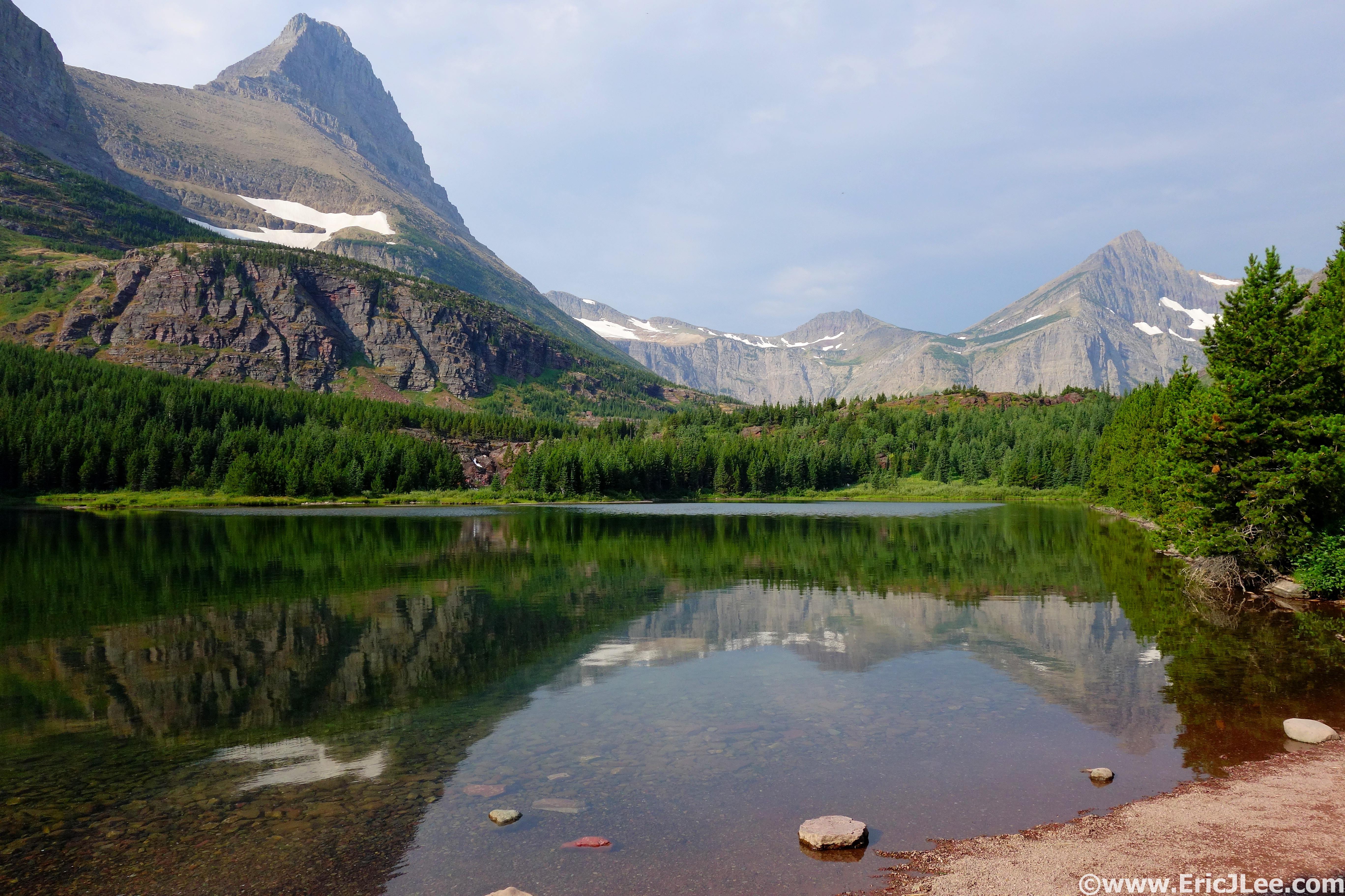
Glacier Grande dipping into the lake.

Lago de los Tres, 2/22

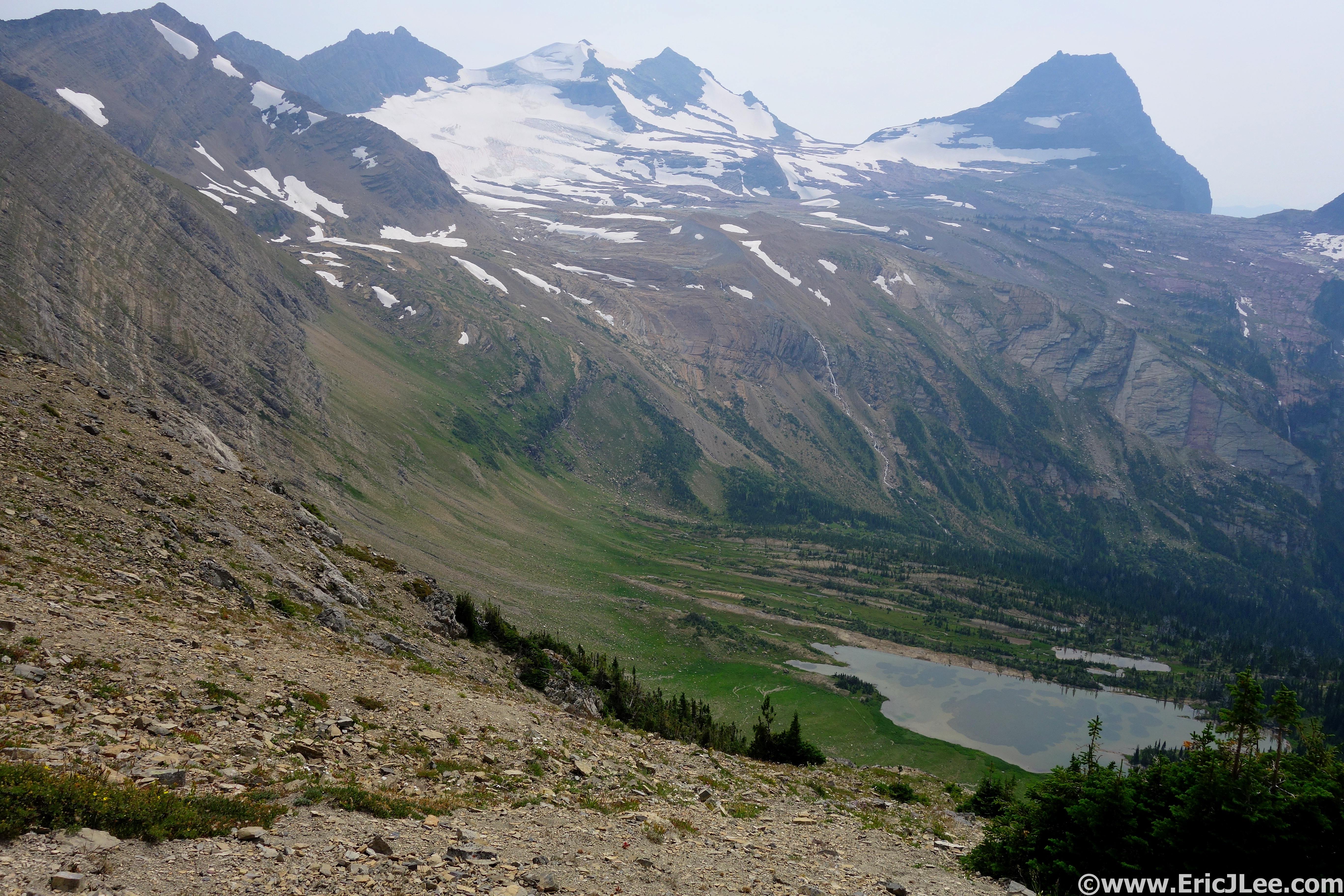
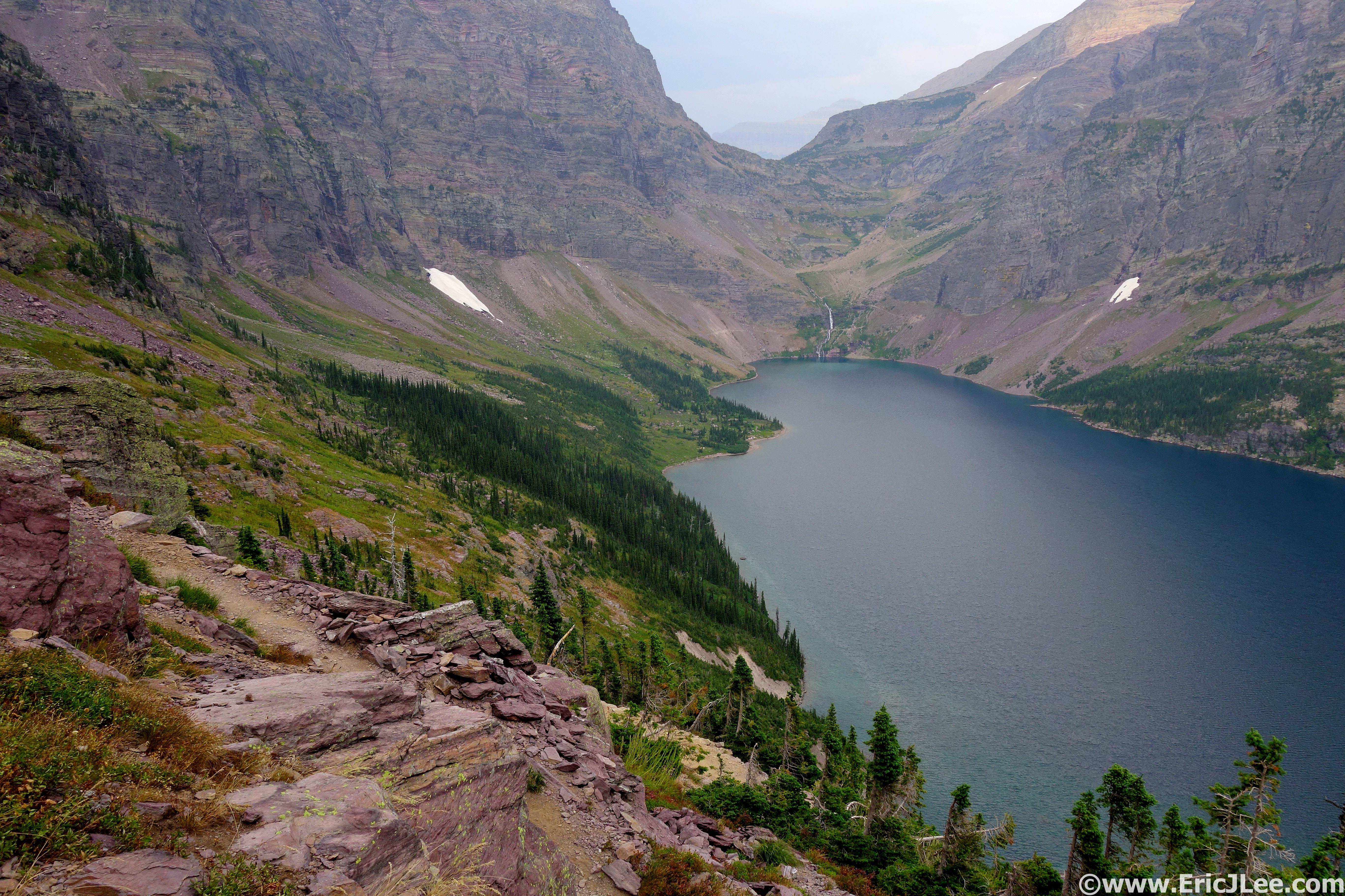
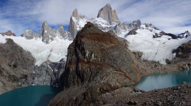
Another casual crack of 9am start, this time I trekked across to the Lago de los Tres trailhead and on up. The trail started with a steady climb, but then leveled off into beautiful runnable tread. The views from Laguna Capri of Fitz Roy were phenomenal on the clear sunny day. The first 9km flew by and then I hit the wall that climbs up to Laguna de los Tres, a steep 1km accent to the top of the moraine and a breath taking view of Fitz Roy and more. I hopped around the right side of the lake to a secluded lunch spot, then to a small hill left of the viewpoint that looked down onto Laguna Sucia and the glaciers. But the day was young and I had energy so I cruised back down the trail, took the spur past Hija y Madre lakes until I finally reached a small saddle where I struck up into the forest on animal trails, bound for Loma de las Pizarras. After bushwacking through the forest I picked up a good use trail that climbed to treeline and above. I entered into the talus and broken shale and continued on the class 2 terrain to a nice view high above the lagunas below. Great view of the peaks, glaciers, and town. 23.1miles, 6400ft, 5:23.

The main trailhead for Lago de los Tres.

Running the smooth trail to Lago de los Tres.

The climb up to Loma de las Pizarras.

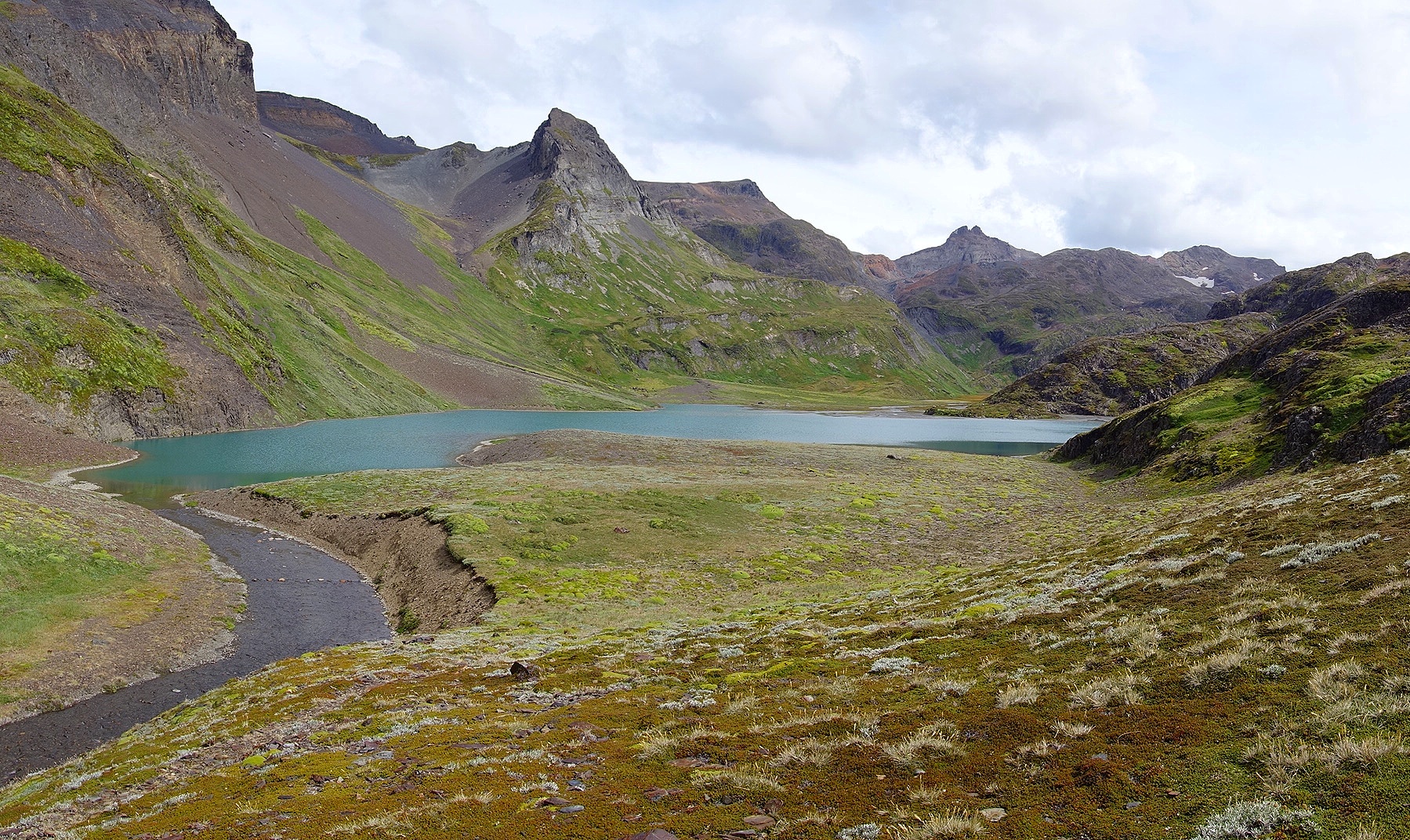
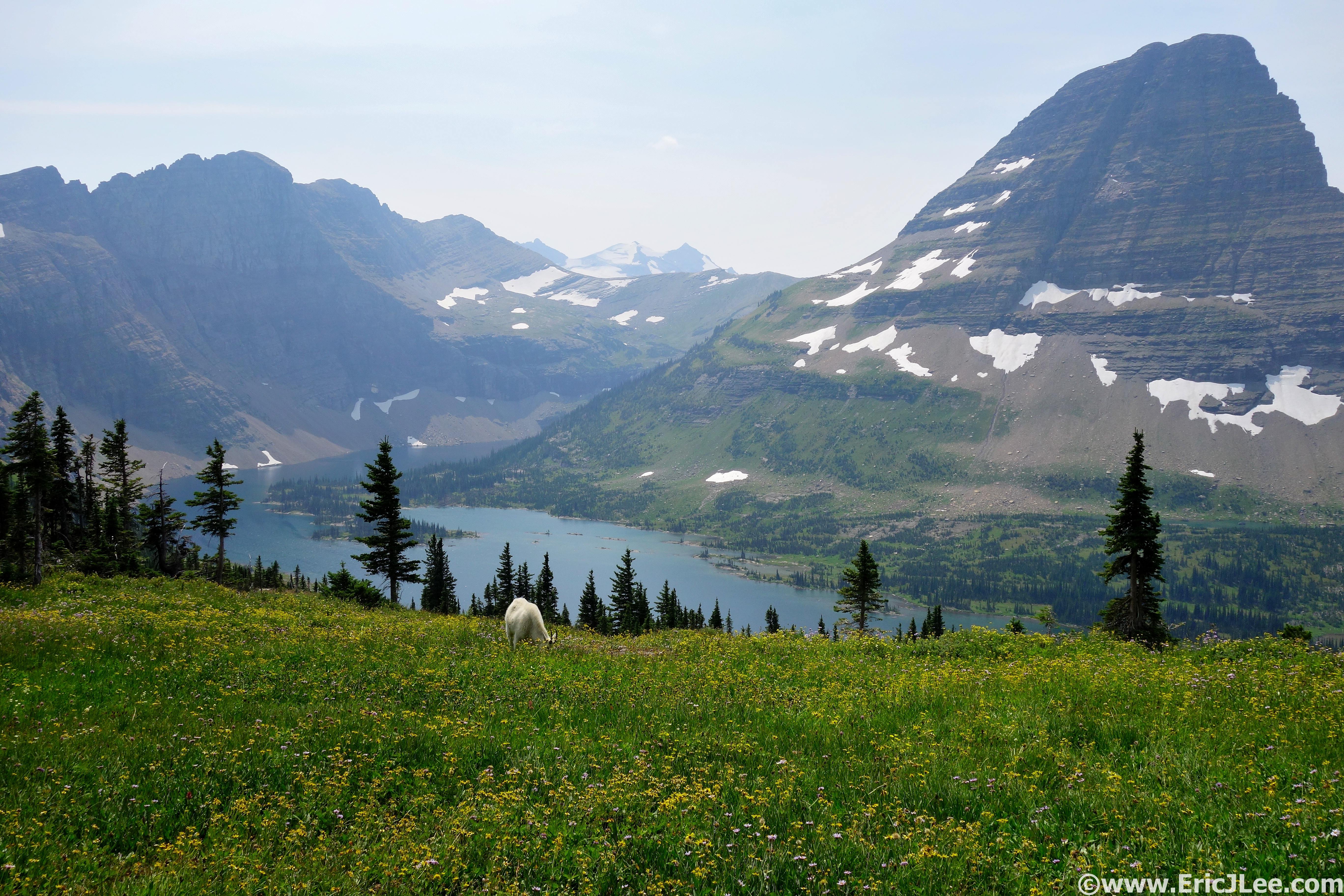
View from Lago de los Tres with Laguna Sucia to the left.

View from near Loma de las Pizarras.

Cerro Torre and the Glacier Grande

Chorrillo del Salto and Mirador de los Condores, 2/23

If you’re looking for shorter and easier hikes near town, both of these are great for the less adventurous or as an off day. Chorrillo del Salto lies about 4km outside of town along the gravel road, so if you hitchhike to the trailhead it’s only 0.5km. Very nice waterfall in a grotto, and if you hike above the falls (left), there are several wonderful swimming holes and secluded spots. The Mirador de los Condores lies only 1km from the visitors center on the edge of town. But it offers some fantastic views of Fitz Roy and the surrounding area, and is well worth the short trip.6.6mi, 700ft, 3:22. 1.6mi, 350ft, 0:39.

Chorrillo del Salto, the swimming holes are a short hike uphill to the left.

View from the Mirador de los Condores, pretty amazing for 20min of effort.

Loma Pligue Tumbado, 2/24

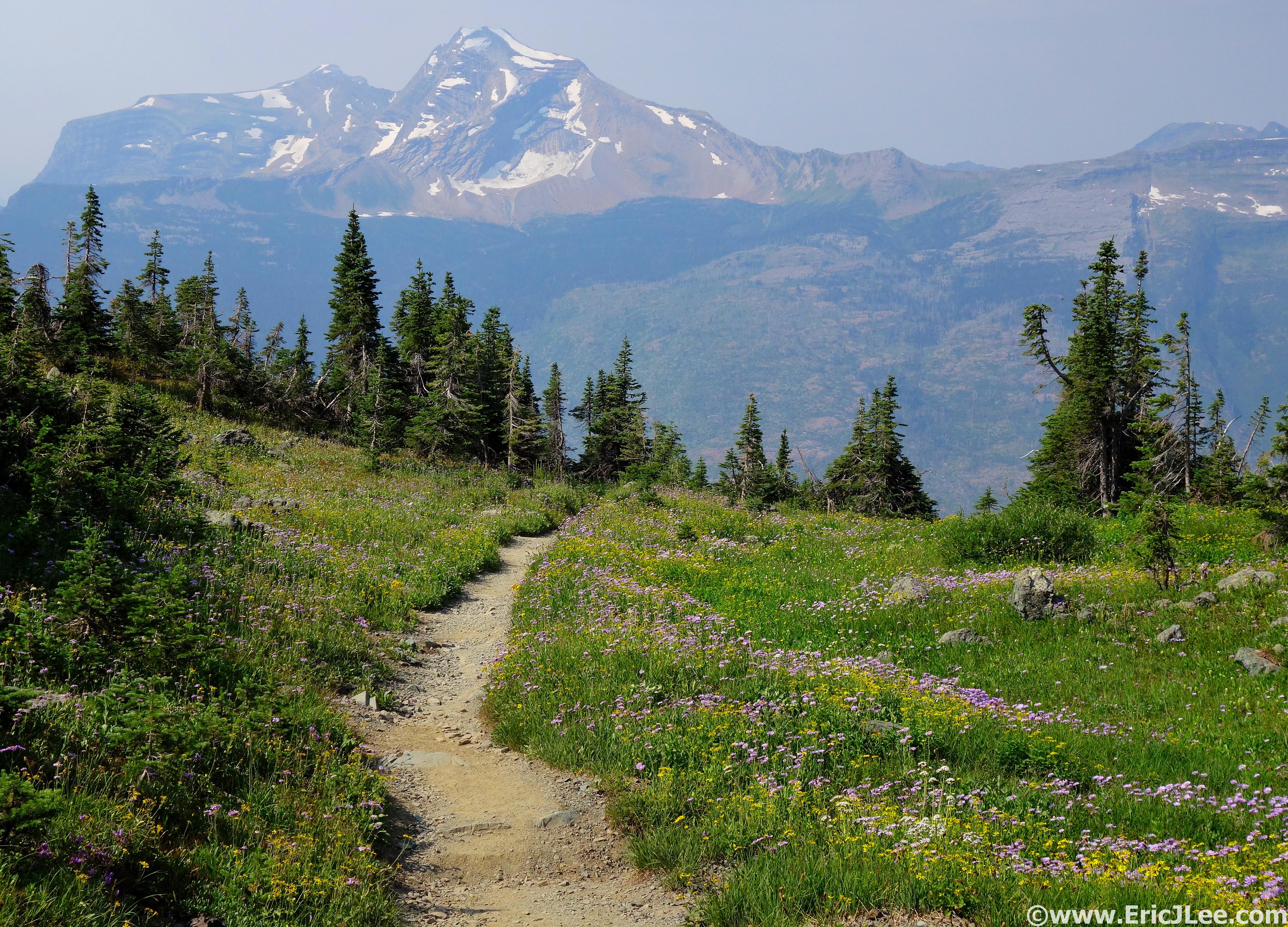
In my opinion the best view (of the popular spots) in the park. From the visitor’s center the trail starts with a steady climb through the meadows and forest up to the junction with the trail to Laguna Toro. From here the trail climbs slowly up very runnable terrain to the mirador, a lovely viewpoint of Fitz Roy and the lagos. The final climb is a steep 1km hike straight up to the summit, where the views are truly breath taking. I enjoyed a 30min break on the summit, all by my lonesome, marveling at the 360 degree panorama. Then I bombed down the trail, the first part being a bit steep, after that it’s a nearly perfect trail run. 23km, 1100m, 3:07.

Junction of the Laguna Toro and Pligue Tumbado trails, super smooth.

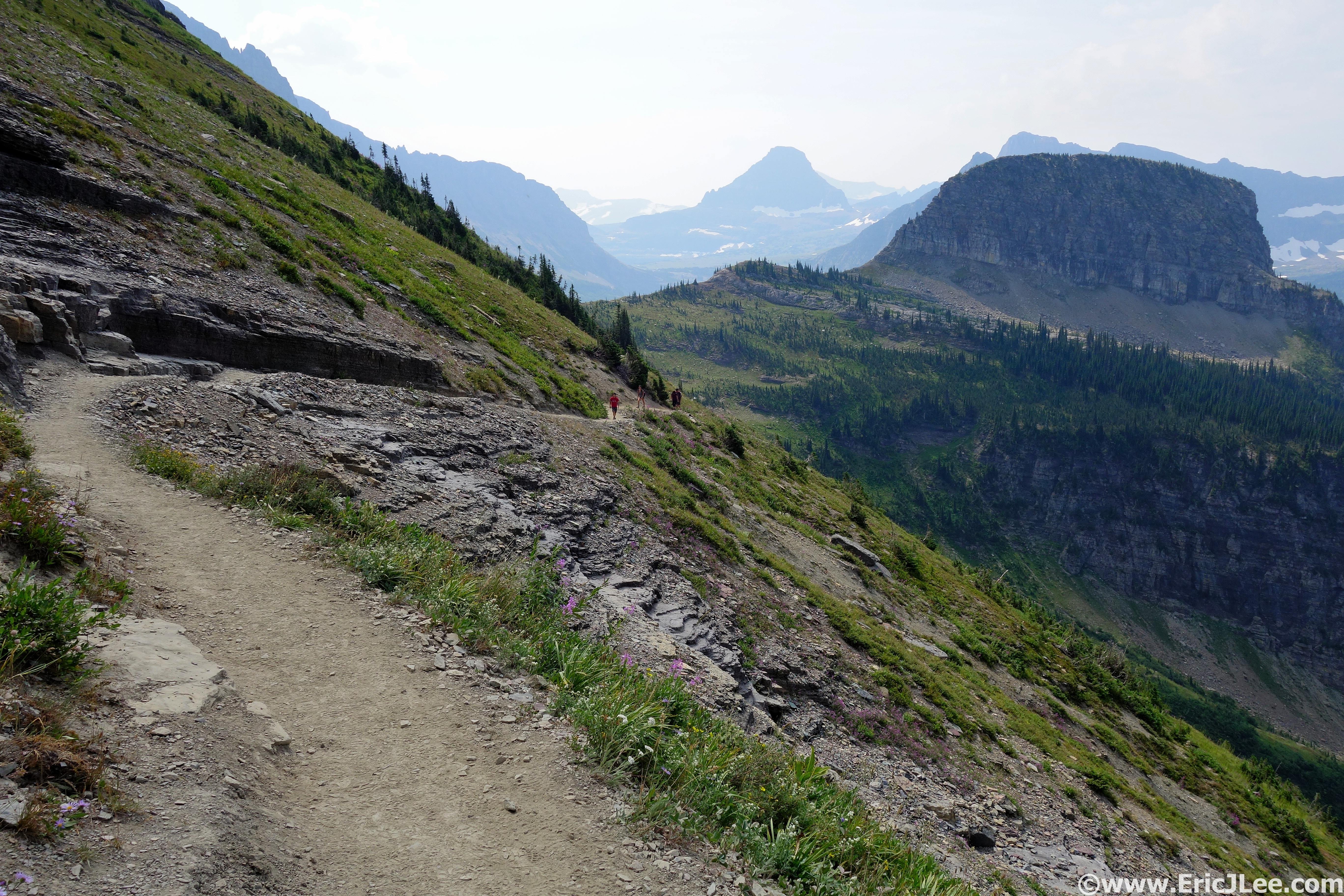
The trail above treeline near the mirador, beautifully smooth with some nice views.

Panorama from the summit of Loma Pligue Tumbado.

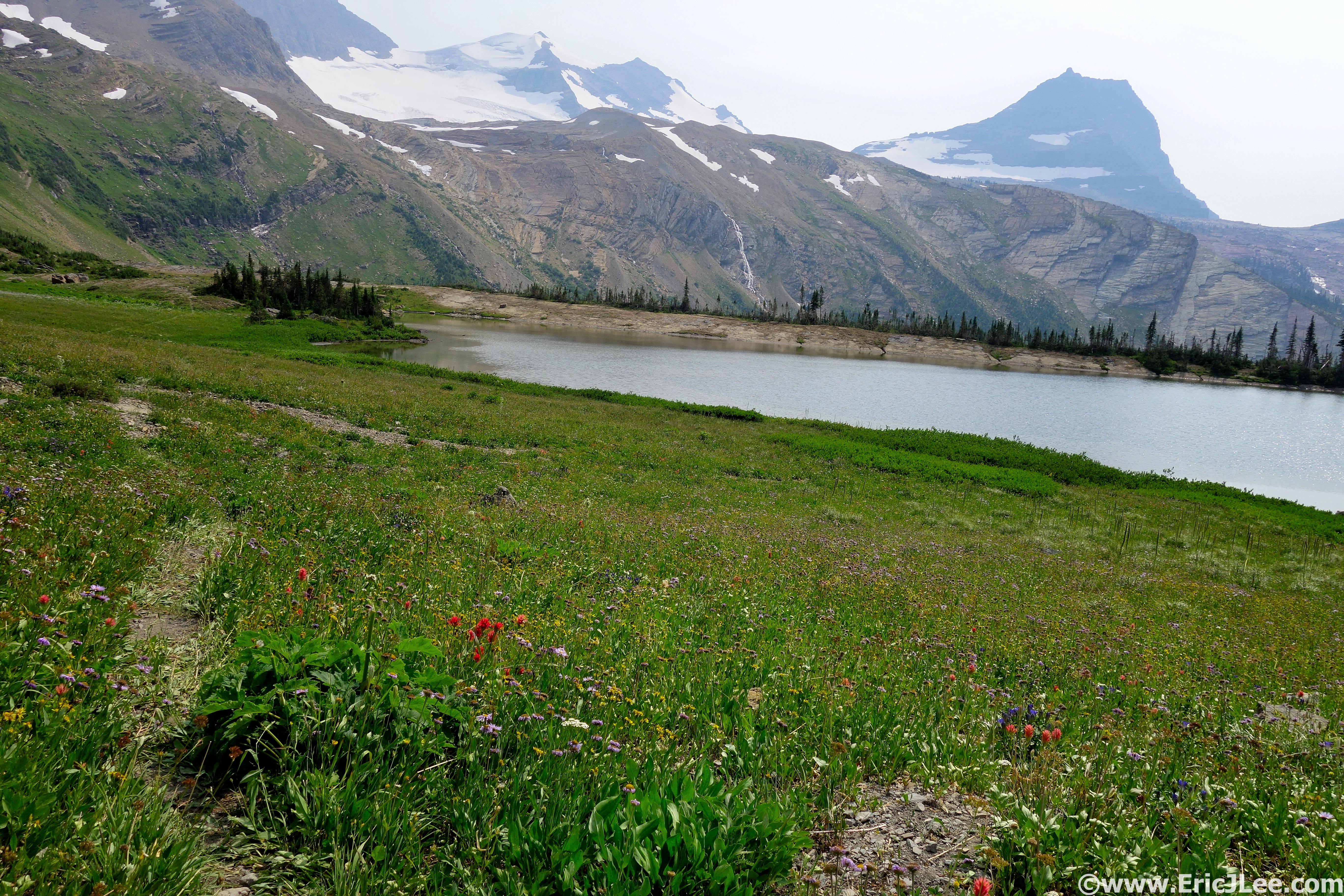
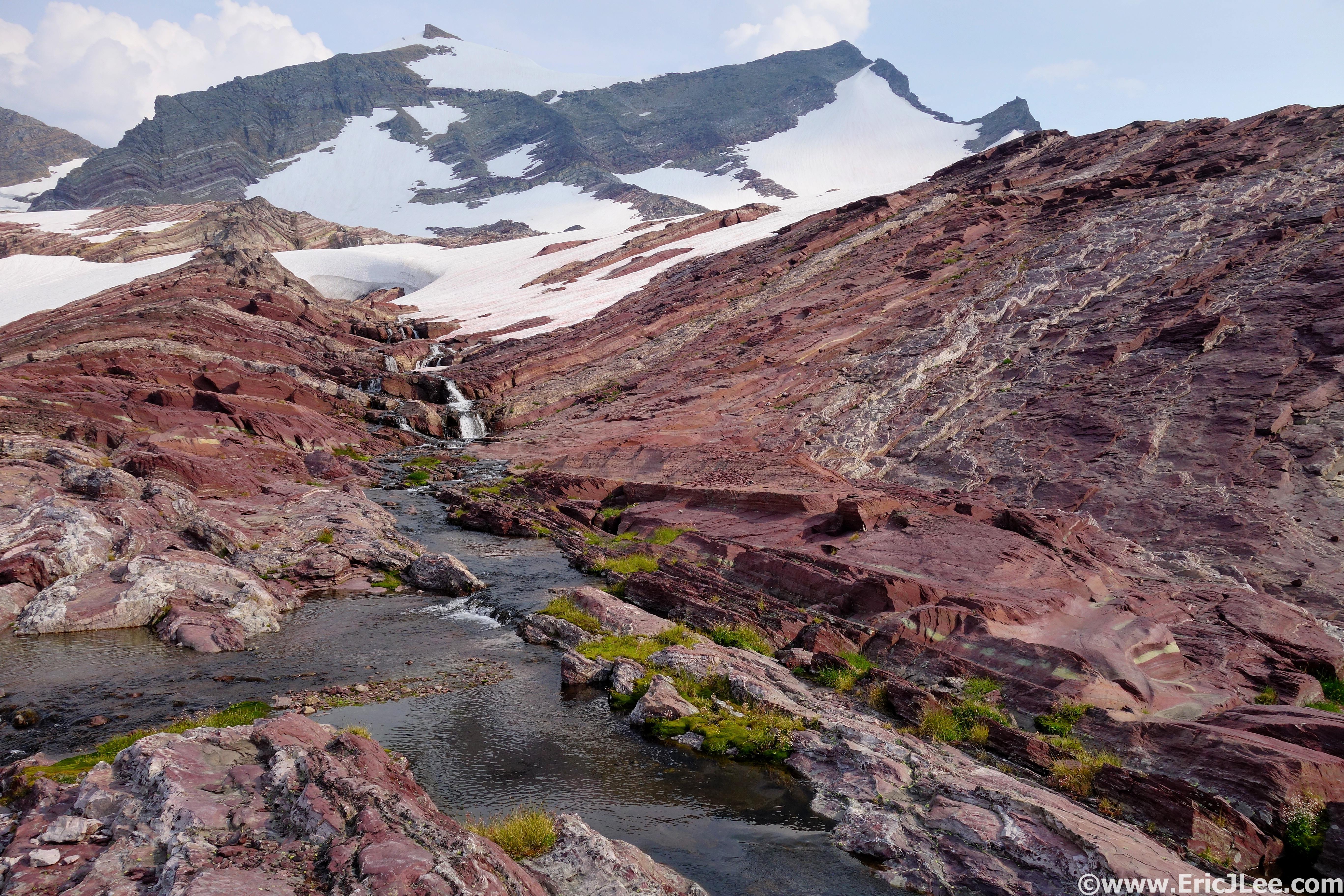
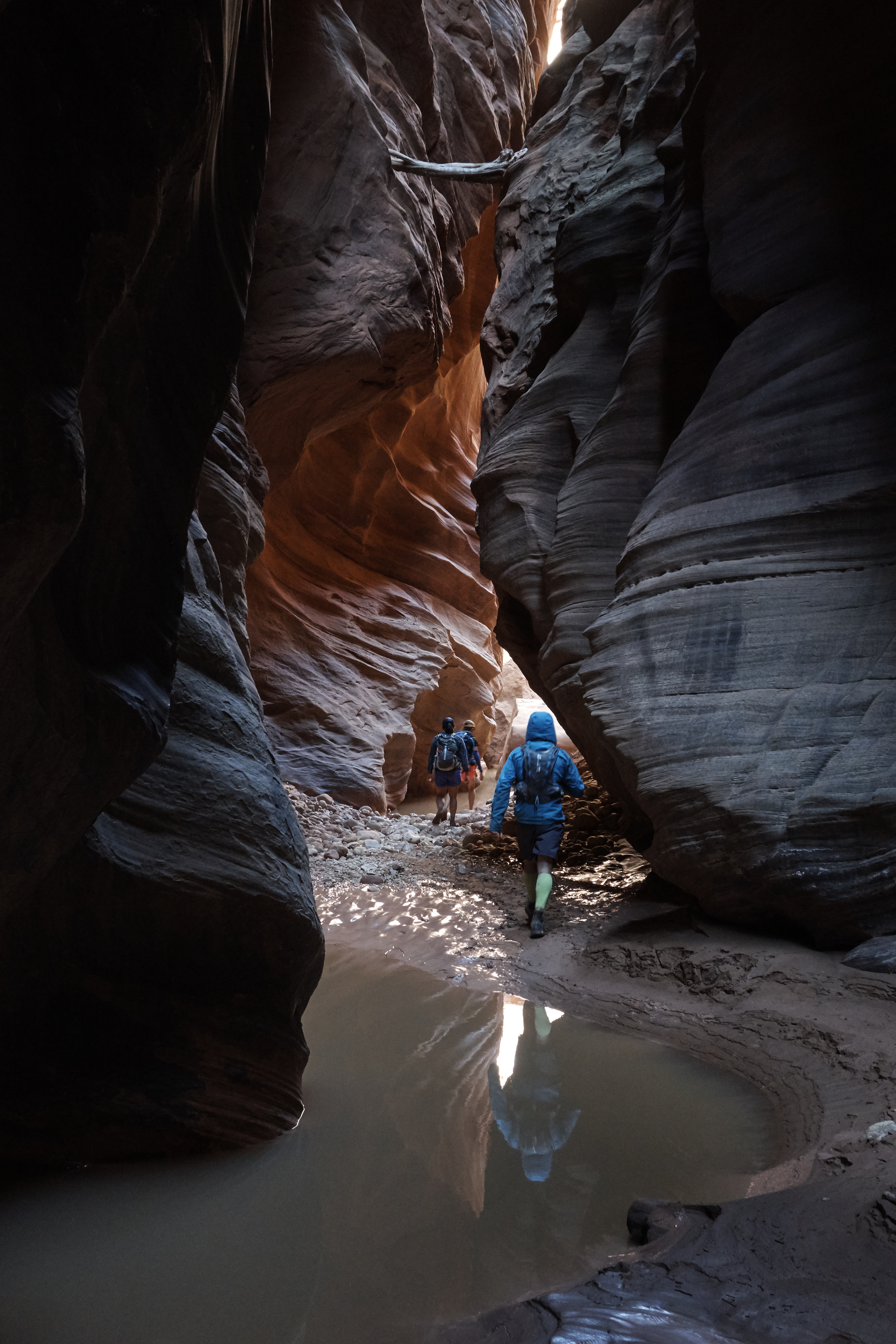
Laguna Sucia & Laguna Piedras Blancas, 2/25I’d hit all the major viewpoints so it was time for a little adventure. If you look at a good Topo map of the Fitz Roy region you’ll see many trails that are not listed on the general tourist maps. These are climbers trails and old trails that are no longer maintained, so require a bit of navigation and exploration. My first destination was Laguna Sucia, starting from the Laguna de los Tres trailhead, follow the standard trail all the way to the base of the final climb. Immediately after the last crossing of the Rio Blanco head uphill 20ft and take a hard left onto an unmaintained trail that parallels the North side of the Rio Blanco, don’t use any of the other use trails along the Rio Blanco, as you will then be forced to ford the river (dangerous). From here rock hop and scramble (class 2) upstream until you reach the Laguna, and the amazing views up towards Fitz Roy. Return the way you came, but to reach Laguna Piedras Blancas head straight across the main trail and head North along the West side of the Rio Blanco. The old trail is eroded in sections, but in general stay near the river as you head North. After several kilometers you’ll reach a broad plateau just before the Rio Piedras Blancas, head up the river for 1km to reach the Laguna, and views of the cascading Piedras Blancas Glaciar. Return the way you came, and if it’s a nice day stop for a swim in Laguna Capri. Lots of slow rough trail, but a fun day of adventure. 19.5mi, 2850ft, 5:30.

Rock hopping up the Rio Blanco toward Laguna Sucia.

Laguna Sucia and Fitz Roy.

Following the Rio Blanco downstream toward Laguna Piedras Blancas.

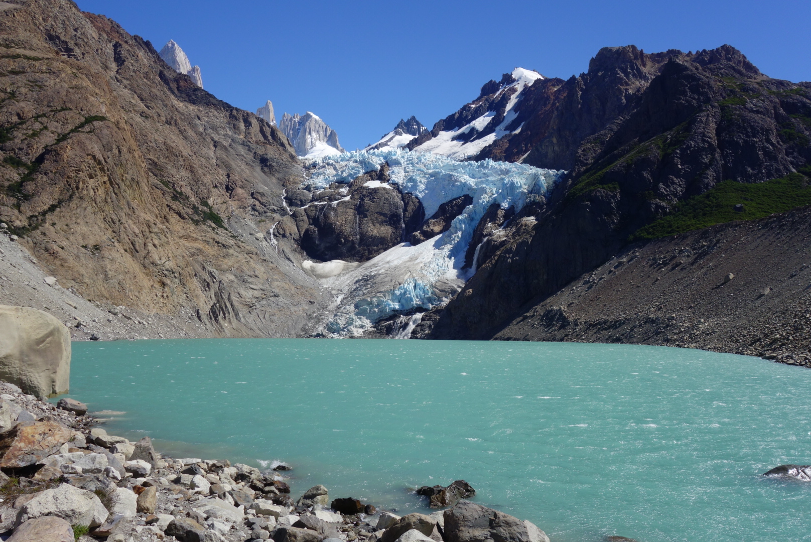
The Laguna and Piedras Blancas glacier.

Afternoon swim in Laguna Capri. Nice way to end the day.

Laguna Toro, 2/26

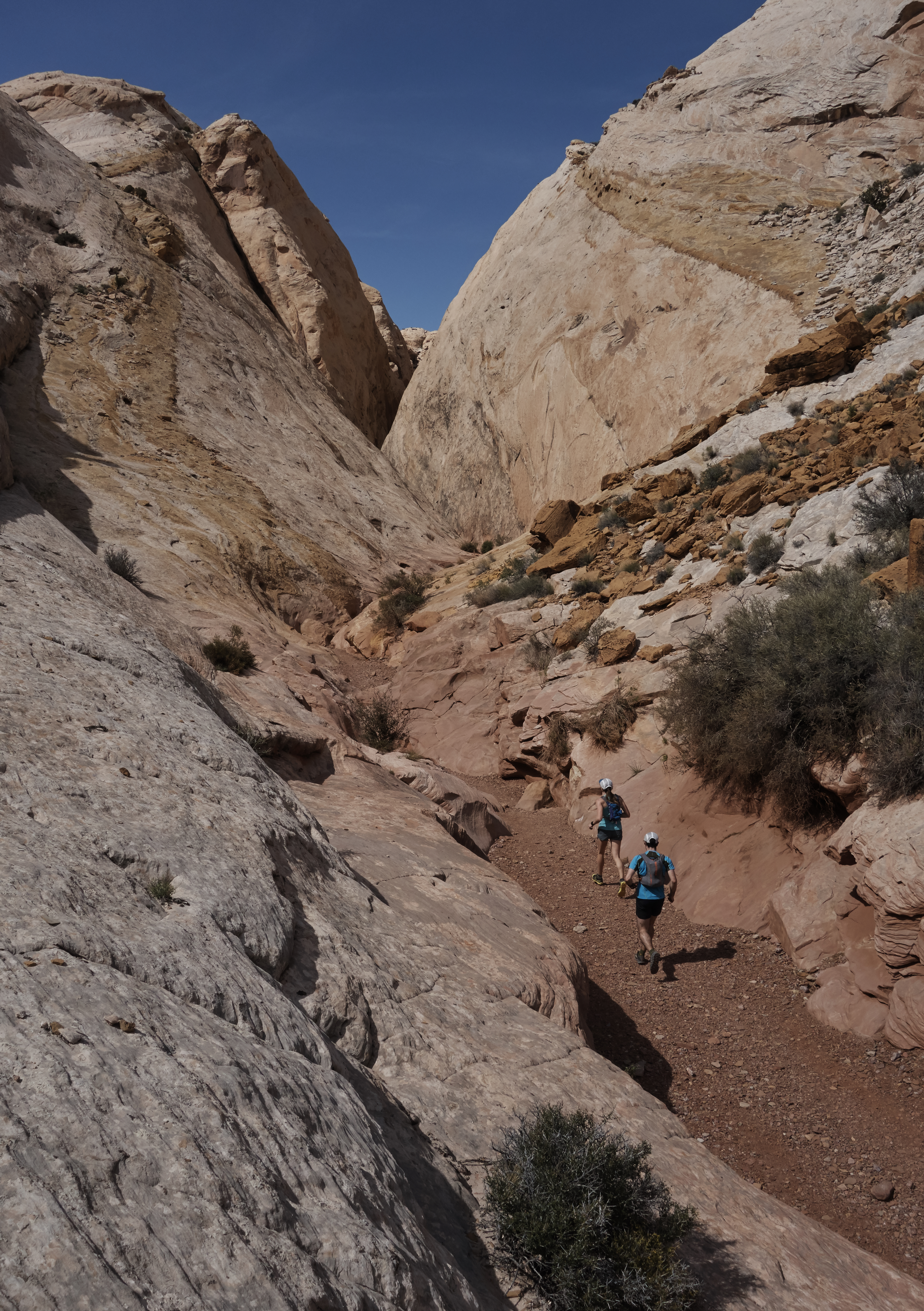
My last full day in Chalten I went for the long run into Laguna Toro and to see the Rio Tunel Glaciar. Starting from the same trailhead as Pligue Tumbado one splits off about 3km up the trail to the left continuing the slow climb through the forest and into castle pastures (muddy mess). Then comes the steep descent to the Rio Tunel valley. All the water sources in the first 12km are contaminated by cattle, so I don’t recommend grabbing water until the rocky delta that feeds into the Rio Tunel. The last 6km to the Laguna is cruiser flat terrain. The campsites and Laguna at Toro are not very pretty, but if you follow the trail behind the Laguna there are several small Lagunas, and views up the deep glacial valley of the Rio Tunel Glaciar. For the more adventurous one can scramble the rocky hill behind the Laguna for a closer view of the glacier and upper valley (class 3-4). Crossing the Rio Tunel requires harness and equipment for a tyrolian traverse. I’ve then jogs out the way they came in, including the now 250-300m climb back up the ridge. While this is a nice quiet valley with good views, it’s not as spectacular as the other runs I did. 26.1mi, 4550ft, 6:19.

Running though some beautiful forests to Laguna Toro.

Dropping into the Rio Tunel valley.

Sending some class 3-4 rock for a better view.

Laguna Toro and another small laguna from my scramble.


Additional Runs not Done:

Lago Electrico

Lago Azul and Lago del Diablo

Lago del Desierto

Paso de Viento (gear required)

El Calafate doesn’t have much to offer besides the massive Perito Moreno glacier. There is a decent walking path along Lago Argentino and an extensive trail system in the privately owned Calafate Mountain Park (11.8mi, 2600ft, 2:08) near town, use at your own risk. The town does have all the necessary supplies and several good bakeries with lots of facturas.

Flamingos and views across Lago Argentino from El Calafate.

Perito Moreno glacier in all its glory.

Calafate Mountain Park view, trespass at your own risk.

How Argentina does pastries, facturas, 10 pesos each.

For the hikers and trail runners out there El Chalten is a little paradise, as long as you don’t mind paying a bit more and dirt bagging it for a bit. Helpful hints are to bring much of your groceries into town from El Calafate, obtain Argentinan pesos before coming to town, and if you reserve lodging via email or in person it’s often cheaper than via a hostel website. I’m sure in the coming years the town will change dramatically, but hopefully it retains its low key dirt bagger charm.

One of the several crappy grocery stores in El Chalten, what you see is all they got.

Social thanks to Vfuel for powering my adventures, the Pro Leisure Tour for giving me lots of time and Hostel Kaiken for giving me a home for the week (Miguel was a wonderful host, email him directly for a discounted price).

Sunrise glow on Fitz Roy.

Trail Running Patagonia

I came to Chile without much of a plan or an idea what I’d be doing. All I knew was there was a lot of wilderness, volcanoes and this magical land called Patagonia. Upon arriving in Chile I started to look around and do a little more research. First thing I learned is that Patagonia is really frickin big. The iconic photos of the Torres del Paine and Fitz Roy only encompass a very small portion of what Patagonia is, a largely undeveloped expanse of rolling hills, mountains and ice. In fact the whole of Chilean and Argentinean Patagonia covers roughly a million square kilometers and stretches for half the distance of Chile from the Lakes District southward to Tierra del Fuego!

Torres del Paine as seen from near the visitors center.

The second thing I learned is that because of crowding a new permit system had been introduced in Torres del Paine NP and things were booked up for all of January and February, well damn. Also to add to the pain, three different websites currently manage lodging (rifugios and camping) in the park and it’s up to you to create an itinerary and sort out how and where to book, not so easy. After trying to line up lodging and work out any itinerary I said screw it, it’s time to be an ultra runner. If you have more questions on the current state of booking O or W multiday treks in the park feel free to drop me a line, as I now know the system quite well, but won’t discuss it further here.

So with all the headaches out of the way, I could get back to the adventure at hand. After a few days in Puerto Varas I caught a flight from Puerto Montt to Punta Arenas ($130) and stayed the night in town to stock up. Then it was off to Puerto Natales and Erratic Rock to lay down done plans. I made the decision to run most of the W trek over two days, to the Mirador de los Torres on day 1 and Valle Frances on day 2 (good weather window). Torres del Paine National Park is about 1.5h from Puerto Natales, and buses only run a few times a day (730/1130 to, 1430/2000 return), and cost between 12000-15000 roundtrip (JB bus is the cheapest). The bus arrives at the laguna amarga visitor center where everyone has to buy a parks pass (21000 in cash for foreigners, line can take 15-60min), and if you want to use it for up to three days of reentry you need to have them stamp the pass. After that you have the option of paying 3000 pesos for a shuttle ride into the park or walk/run the 7km alongside the dirt road.

If you choose to run or hike the road the views are actually pretty good.

NOTE it is technically illegal to run in the park per their rules, silly as it may be, make your own decision about the rule. Though no one bothered me, but make sure to be respectful of others on the trail as it’s very busy.

I paid the shuttle fee and was dropped off at Torres Central where I started jogging down the road and hitting the double track trail, taking the spur towards Chileno and the Torres. The trail was quite runnable up to Chileno, but there was a wicked wind that rushed down valley throwing dirt at us. After Chileno one enters a pleasant forest and then starts the steep trek up toward the Torres. The trail is a bit rocky, but easy to follow with plenty of clean water access (I never treated any water). Soon I crested the moraine and an awesome basin of granite lay before me, holy $h!?. It had only taken me 1:40 to get up so I spent 30min just relaxing, taking photos and just reveling in the majesty. Then jogged down the trail all the way back to Laguna Amarga and the bus pickup at 14:30, taking care to be respectful of all others on the trails. Fantastic half day run, amazing view, and a must see if you’re I the area.

Starting the trail into Torres del Paine NP.

Some super smooth single track through the forest near Chileno.

Views down the last hill before reaching Torres Central.

Day 2 saw me doing the same, but skipping the 1h line. This time I headed for Cuernos and Valle del Francés. The trail to Cuernos was buttery smooth and views of the lakes and mountains were phenomenal. I cruised on past Cuernos and Francés to Italiano camp and quickly struck up Valle del Francés. The trail in this middle section of the ‘W’ is rocky and rooty, so much slower travel. The view from mirador Francés and Britanico are phenomenal, a combination of RMNP and Glacier NP; soaring peaks and glaciers abound. I slowly wound my way back down past the crowds and headed toward Paine Grande. From here I had the option of catching a ferry (18000 pesos), but had 3h so decided on the long slow route 17km back to the visitor center. The trail started with rolling hills and spectacular views across Lago Pehoe toward the Torres, then flattened out and was a grind back to the visitor center. I finished off my long Trans-Torres NP run of 55km in 7:50, not fast, but beautiful with lots of photos taken. The final piece was to catch the bus around 1830-1900 back to Puerto Natales, finally reaching town at 2130, hungry and tired.

Lake side single track and expansive views at the start of the Torres park.

A little stint along the lake shore enroute to Cuernos.

VALLE deL Francés, pretty awesome views.

Looking back at the Cuernos from the trail.

Looking back across Lago Pehoe at Torres del Paine.

The next day I moved on to Ushuaia and Tierra del Fuego by bus (12h). Quaint little town with an abundance of fantastic runs within a few kilometers of town. In my opinion a great place to post up for a bit and explore, because there are also great facilities available. I’ll briefly mention the runs I did, but note there are quite a few more I didn’t do.

Ushuaia and Tierra del Fuego on a nice day are pretty spectacular.

Day 1 I followed the trail up Cerro del Medio to the summit for a view of town, the surrounding mountains and the Beagel Channel. I descended a faintly marked trail on the west side into the forest, squished through a peat bog and over to the Glaciar Martial view point before jogging back to town 30km).

View from the summit of Cerro del Medio.

Looking down on Ushuaia and the Beagel Channel from the summit.

Following cairns through the scree and lush greenery.

For peats sake. Looks innocent, but it’s like walking on a sponge, soft and wet.

All the water in Tierra del Fuego makes for some lovely scenery.

Day 2 a few friends and I hitch hiked into the National Park, paid the entry (160 pesos) and followed the trail up to the summit of Cerro Guanaco, another fantastic view point with amazing views of the entire park. The trail isn’t long (16km), but it’s a 1000m climb with some steep and muddy sections.

The final pitch to the summit of Cerro Guanaco, pretty decent views.

360 degree panoramic views from the summit, pretty awesome.

We made a friend on the summit, a local zorro (fox).

So it rains a lot in Tierra del Fuego, and sometimes things get muddy.

Winding or way through the trees down Cerro Guanaco.

Day 3 I went big and set out from the hostel through the dirt bike park and up into Valle de la Oveja. Fantastically runnable trail high above the valley, finally topping out at the pass in a barren scree field surrounded by mountains. Then I dropped down into the lush Valle Andorra, with a spectacular side trip to Lago Caminante and Superior. Both are amazing blue glacial lakes set in deep green valleys. The run down Valle Andorra was slow due to very muddy trails mixed with some beautiful single track. The 35km run took me 5h, and I was able to hitchhike back into town with a local, saving me 11km of road. Fantastic loop, with almost no one on the trail and expansive views.

Climbing up Valle de la Oveja.

Lago Superior and it’s compete solitude.

Descending Valle Andorra through some beautiful forest.


Notes for Patagonia:

Crossing between Chile and Argentina for US citizens is now fairly easy. No fees, just stamps and passports needed. But don’t bring any fruits, vegetables or meat.

For those coming from the US or Europe, bring a lot of your local currency to exchange  (or use without exchanging) because ATM fees are high and ATMs are often empty in popular places.

Many of the cities aren’t near the best trail running, you’ll have to do some work to get there; bus, rent a car, hitchhike, or ride a bike a long way. Ushuaia, El Chalten and Bariloche are the exceptions, with fantastic running right out of town.

If you’re having trouble finding trails, turn on strava and check segments for running and riding. I’ve used this to find all kinds of trails. You can also contact locals and trail groups for information, though response can be slow.

Traveling around Patagonia is fairly easy by bus or hitchhiking for the more adventurous. Cheap flights also exist within country, but crossing borders is expensive. Chile is cheaper than Argentina.

So that’s just a few thoughts and lots of photos, next up El Calafate and El Chalten. Special thanks to Vfuel for powering my adventures and the PLT for making all the fun possible.

Lago Caminante and all the colors.

Travelers Guilt

Planes, trains and buses. Sometimes you’re packed in like a sardine, other times you have half a plane to yourself. In route to Malaysia.

In the developed world many of us are very fortunate to have the means and the opportunity to travel, both domestically and internationally. I could write pages on the benefits of traveling to different cultures and becoming an international citizen, but that’s not what has my brain cranking. No, what has me pondering what it means to be a traveler is something I’ve deemed “travelers guilt”, let me explain. During my time in Asia I spent a lot of time talking with locals, learning about their culture and lifestyle and sharing mine. Both in Nepal and Myanmar I talked about my travels to many different countries and cities and about all of what I’d seen. For most people in the western world, you may be jealous of the things I’ve done and seen, but the fact that I’m doing them is not a surprise to you. Most of you probably know a dozen other people who have taken off on a several month long journey (or longer), to distant far off lands.

Christmas festivities ibn the Seoul airport, complete with a woman singing songs from Frozen, in Korean.

Most people in the developing world don’t have this luxury. Life focuses on family, friends, home, farm, school and the essentials. Many people in SE Asia and Nepal have never been out of their own country, and some may not have ever left their districts/regions. Traveling for pleasure is just not something they think about or that is part of their culture, so to talk to world travelers opens up a world of different experiences and possibilities. So far, this is all good, sharing different experiences and ideas.
Now the guilt. Both in Nepal and Myanmar the question came up about how much it costs me to travel; hostels, airplanes, buses, visas, etc, there are a lot of different expenses that go into traveling internationally. I’m a fairly thrifty traveler, but flights still cost hundreds of dollars, visas upwards of $150 in some countries. My new friends asked me about all these things and I wasn’t going to lie or sugar coat anything. But as I recited some of the numbers I realized, even my cheap $400 flight to Asia was an amount of money that they could live off for a month, it’s an amount that takes them some time to wrap their head around, and we spend it merely for pleasure.

Our adopted Burmese family, they invited us to their family picnic, gave us beer and food and did out makeup, because…

Teaching my Nepalese kids about America and world geography.

I began to feel very guilty and extremely self continuous about my travels, and spent my several days of transit to Hawaii (via Thailand and Korea) pondering what this concept really meant. Should I not be traveling and instead just donate my extra money to charities, should I travel but share my money more freely with as many locals as possible, or is this just the nature of economic inequality? In the end I came back to the advantages of international travel for our society and individuals. Awareness, understanding and sharing our cultures brings tolerance and in my opinion makes us all better and more compassionate people, but that’s just my opinion on how I travel and what I want to get out of travel.

Wedding in the village of Shishaghat. Family, friends, food, dancing and everyone (even me) is invited.

But this doesn’t mean “travelers guilt” hasn’t changed how I travel. Since there are huge economic disparities between the western world and developing countries I think those of us do have a responsibility to do the little things to help those who need it most. Don’t stay in big corporate hotels instead find a small B&B or guesthouse. Buy from street vendors and small shops instead of big commercial operations (guess this is true for the US too). And even though you have more money than the locals don’t flaunt it, be respectful. I’ve started trying to spread my money around when I can, but not spending more extravagantly than I normally would, just being conscious of where my money goes. I’ve seen way too many people throwing money around and treating the economically less fortunate as slaves, which just disgusts me.

Shopping the street markets of Yangon, Myanmar for fruits and veggies.

Most of you reading this were born with a similar level of privilege that I was, and I feel it’s our duty to be responsible citizens and try to help those wonderful hard working folks who offer more than a simple product, but a story and friendship (I guess this is some degree of socialism for mankind). I welcome different thoughts, opinions, and arguments for/against what I’ve written above. These are just my ponderings and musings and I’d love to hear other opinions or if anyone else has struggled with this topic. For now, I’ll keep on traveling, but am a little more aware of how I do it and how much of a privilege it is. Thanks to ask those who have shared this journey with me, opened their lives to me and whom have helped me grow along the way.

So no matter how you travel, enjoy the ride. The people and places are what make the experience, not how much it costs.

Where Fire meets Water; Volcano National Park Ultra

​An ever changing landscape, Volcanoes National Park is one of the few parks that’s still being molded on a macro scale. Not one mm a year like the grand canyon or a few inches like the redwoods, but in some places dozens of feet of new land are added to this national park by the flowing bubbling lava. Ben and I spent a rainy night at camp along the Hilina Pali Rd at Kulanaokuaniki, but awoke at first light to clear skies. After a short drive we located the unmarked trailhead along Hilina Pali Rd  (sometimes called the Halape trail), parked in a small pullout and set off along the cairned, but barely visible route toward Halape.

Ben starting down the Halape ‘trail’ definitely unmaintained.

Following the ‘trail’ through the grass, really just a bunch of cairns.

The ‘trail’ started out as a faint path well marked by cairns, but we were soon dumped onto an old road that was horribly overgrown, but still quite visible. We thrashed through knee to waist deep grass for a few miles until the road disappeared into deep grass and we were left with nothing but a line if cairns to follow. The trail began to descend southward toward the ocean rather than traversing back toward the Chain of Craters road as we’d expected, but it was so well marked we continued forward. We descended steeply down some old switchback to the Halape junction (2:15), much further west along the trail than we were expecting because on the map the unmaintained trail was supposed to drop us onto the Keauhou trail closer to Chain of Craters road. Sadly we’d missed the trail down to Halape and decided that because of the slow conditions we’d alter the route and continue on the loop minus Halape.

Ben making his way across the Ka’aha trail, a major trail in the park.

Lava tube near Ka’aha, a little exploration.

As we started across the Hilina Pali trail toward Ka’aha it was very evident that the day was going to be a slow trudge. While this ‘main’ trail was very well marked we were wading through knee to waist deep grass the entire time and almost nothing was runnable. We passed through a lovely grove of trees (shade!) and then slowly descended toward the beach at Ka’aha (5:45).

At the ocean near Ka’aha, weeee.

The rolling lava fields between Ka’aha and Pepeiao

The Ka’aha shelter is a funny little shack with a rain water tank and a bathroom near a protected swimming bay. We dipped our hands into the ocean and continued onward along the coast. The character of the coast dramatically changed, and we soon found ourselves running across buttery smooth black lava dunes. It was by far the most runnable and most enjoyable section of the entire day. We spent several miles cruising through the barren lava field, the ocean on one side and the Hilina Pali cliffs on the other, finally arriving at the sandy promontory overlooking several sea arches and the crashes waves of the Pacific. This is what I pictured Volcanoes National Park to look like, barren lava beds, towering sea side cliffs, crashing waves and compete solitude, it had only taken us 6 hours to find it.

Seaside living, lava, arches, big waves.

Pepiao shelter high in the hill side.

We then left the ocean and started the long, slow, hot trudge up toward Pepeiao. As we ascended the rocky lava the wind died and we started to bake in the hot sun. I was definitely fatiguing so the pace died a bit. We finally reached the Pepeiao hut perched high on the Hilina Pali with expansive views I the lower park (6:45). We again refilled our water and proceeded to immediately lose the trail coming out of the cabin. After 10min of bishwacking through the grass we finally located the over grown trail headed uphill away from the cabin.

Ben leaving the Pepiao shelter into the deep grass.

Less than a mile out from the cabin Ben began to cough and some horrid smell was tickling my nose, it took us a few minutes but we finally realized it was SO2 fumes from Kileuea, which made both of us a little sick and uneasy. Over the next few miles we’d continually get inundated with toxic fumes, go through coughing fits, then push onward. Finally as we neared the Hilina Pali overlook we left the fumes behind and were free and clear, thank god nothing lasting. The Hilina Pali overlook is a quiet little cabin with good views of the coast and lava field below, but it’s hard to gain perspective I the area from so far away (8:30). All that was left was to jog the final 3.5 miles of road back to the car and closer the loop. We arrived back at the car at 4:10, 9 hours and 10 minutes after starting, having covered between 26-29 miles (unknown because of trail changes and wanderings).

One of the things I’ve learned from my first six national park ultra run adventures is that not only is there a huge diversity of landscapes within the park system, but often this huge diversity applies to a single park. Volcanoes NP transitions from rain forest, to subtropical, to chest deep grasslands, to barren lava beds and finally sandy beaches. And while the route we ran (really mostly hiking) in Volcanoes was not exactly what I thought it would be, it lived up to the showing the true character and diversity that Volcanoes National Park had to offer. The variety of landscapes, the ruggedness of the terrain, the battle between man and nature (nature is winning), and some beautiful solitude. So the project continues on, with six National Park ultraruns competed, and >40 to go, I’ve got a lot of work to do.

NOTES: 

First off Volcanoes National Park suffers the same issue as many other parks, a gross lack of funding. In fact we later found out that the park had laid off all their trail crews for months prior, explaining the overgrown trails. Because I’d this don’t expect super smooth runnable trails, but more an adventurous bushwack, bring a good map. Camping at the ocean side shelters would be quite nice, but Pepeiao want very inspiring and was full of red ants. Since lowers volcanoes is mostly dry grasslands don’t expect to find any water except for the rain collection at the shelters, inquire with the park as to how full the catch basins are and whether the trails have been maintained at all. Note that because of the volcanic activity this run does not include the active lava flows of Kileaua or Pu’u O’o, but both are must see side trips, especially where Pu’u O’o flows into the ocean. So if you’re looking for solitude in a unique volcanic moonscape, give lower Volcanoes National Park a go. Thanks to Vfuel for supporting my habits and to Ben for joining me for this adventure.

Lava flowing out of Pu’u O’o into the ocean at sunset.

The lava glow of the Kileaua crater at sunset.

Navigating Medical help in Chile

Morning stroll through the Plaza de Armas on my way to the clinic.

First off, I’m fine nothing major, but I contracted a nasty case of poison oak in California a week ago which has spread to all my lower extremities and has my left leg swollen as if I’d run 100 miles. I’m quite allergic and since it wasn’t improving I made the venture into the wide world of Chilean healthcare for a little assistance.

My swollen and rash covered leg, hard to appreciate my cankle and giant calf.

First off I was relieved to learn that the Chilean healthcare system is quite good. The network of pharmacies is wide, but while one can get many things over the counter, corticosteriods are not one. So my choice was a ‘hospital’ or a ‘clinica’ to get a prescription. Hospitals are government subsidized facilities while clinics are privately run (and often better), so I opted for the Clinica Davila near downtown Santiago. My traveler insurance doesn’t cover small medical visits, so that was of no use, so it was all going to be out of pocket.

Entry to the Clinica Davila, looks legit.

I walked in the main doors of the clinic and up to the front desk, where it became apparent I’d be doing my transactions in Spanish, I wanted to practice and what a way to learn. I was sent to a check-in desk where I was able to get my name on the list for a doctor consult, then came the fun adventure of getting my information in the system as a foreigner without insurance. The guy at the payment desk had a little trouble, but we figured it out, $45 later,  then came the wait to be called in to see the doctor. An hour later I was called in; the doctora examined me, we navigated my issues with my limited Spanish, she looked at my leg and prescribed an antibiotic and a steroid and off I went.

Bottom is my appointment form, top my prescription, mmm steroids.

I stopped in at the local Ahunada farmacia and picked up my meds without issue ($18). In total the process took about 3h, but if I didn’t speak any Spanish I’m not sure how I would have done it. So just a word of warning, that while the healthcare in Chile is wonderful and very available, finding English speakers is a tough task and be ready to fumble your way through the process if you don’t speak Spanish. Here’s to hoping the swelling goes down quickly and I can get back to normal. It’s been a rough start to 2017, full of all kinds of learning experiences.

I am Me. How do I Prove it?

Fu&@#%*, was one of the many curse words that flew from my mouth when I saw the window of our little Nissan smashed to bits and realized my backpack was gone along with my cell phone and wallet. I had no ID (none), no credit cards, no cell phone and really no way to prove who I was.

Smashed window and everything gone, well not everything. They left or dirty clothes.

The short of the lead in is I had misguidedly left a backpack containing my passport, travel journals, camera SIM card with 1000 photos, along with my wallet and cell phone in an area known for break-ins and thefts and was now paying the price. So that sucked, but now came the real question, could I get myself to the mainland via airplane without any credit cards or ID, and how does one get new ID when you can’t directly prove who you are? Hopefully my misfortune can help others through such troubles if they befall you.

Step #1 contact the police. Surprisingly the police were over within 15min; surveyed the scene, took down my name and address (no ID) and filed a report. The police were able to give me a letter stating I’d filed a police report that my ID was stolen, this would come in handy later.

Step #2
canceling stolen goods. Thankfully Ben still had his cell so we were able call in and cancel my credit cards and cell phone immediately. Later that night I went online to cancel my passport and global entry card, nothing needed to be done for the driver’s license.

Step #3
returning the rental car. Since the car was still perfectly drivable Economy Rental said nothing needed to be done right away. We took some photos and later that night drove to the rental car company to return the vehicle. They examined it, took down some notes then explained that once they got it repaired they’d contact me as I’d have to front the payment. Thankfully since I paid for the rental with my Chase Sapphire card they will be reimbursing the cost of the repairs (check your credit card). I also had the option of going through my car insurance, but opted not to. Also note that one cannot take out a new rental car without BOTH a driver’s license and a credit card, thankfully some good friends helped me out in the ride department my last day in Hawaii.

Step #4
airport travel and flights. I had a scanned copy of my passport so hoped that would help. Problem #1 you can’t pay for bags without a credit card. So I was instructed to buy a prepaid visa for a $5 fee to pay for my luggage, ugg. But with the passport copy they let me checkin (Hawaiian air). Problem #2 TSA, They looked at the copy of my passport and said that it was not acceptable. He called over the head officer, who first called the police to verify the police report, then called Homeland Security (I assume) and proceeded to ask me 6-8 random questions to prove my ID, and I guess I passed because they let me through after a thorough pat down and bag search. I made it! Apparently this also works if you’ve simply forgotten your ID but need to get through an airport.

Step #5
navigating life. There are quite a few things that one can’t do without an ID and/or credit card. You can’t buy food on an airplane, buy anything online, enter federal buildings (like a passport office), buy alcohol, enter a bar, among other things.

Step #6
obtaining ID. Since I had flown to California getting a new driver’s license was off the table, BUT if you have a flight within two weeks one can get an expedited passport. So I had to book my flight to Chile THEN they would allow me to apply for a passport, so I booked my flight, called the SF passport office and made an appointment. Now the tricky part, proving my identity without any actual ID. Without ID I would need to provide a whole bunch of secondary identification. Thankfully my awesome housemate sent my California driver’s license (from age 20), my CSU student ID and my rec card. In addition I printed out old bank records, tax forms, utility bills, medical records, insurance cards and a copy of my birth certificate and passport. After getting a personal escort up to the passport office (because of no ID) I presented my DS-11 and DS-64 forms along with the giant pile of paperwork to two separate people. After looking through all my paperwork he grabbed the four copies of photo ID and had my mom sign a DS-71 vouching for my identity, but leaving all the records behind. In the end it was fairly painless and my passport was ready 24h later ($195 total fee). If I didn’t have someone to vouch for my ID I probably would have needed all the extra paperwork.

Step #7
 driver’s license. Getting a new license (lost or stolen) in Colorado requires one to go into the department of revenue to apply for a new ID, a process I’m not looking forward to, but it should be mailed within 30 days. 

I have ID again! Hooray for expedited passports.

So while it’s a pain in the ass to go through these processes it’s not too difficult, just time consuming. The really sad thing was losing my journals and photos, but life goes on. Lesson learned, don’t leave anything in cars in Hawaii, always split up IDs and credit cards and carry valuables with you at all times. Also make sure to back up cellphone contacts to an online source, I only had some saved. Now that I have a verifiable identity its off to Colorado for a few days on the 17th then Chile on the 22nd, let the adventure continue!

There is always a light at the end of the tunnel, and I got to hang out in California for a bit.

House of the Sun: Haleakala Ultra Run

I grew up vacationing on the garden isle of Maui, splashing in the waves, building sand castles and occasionally fearfully snorkeling. As I grew older our vacation adventures grew a bit bolder, several times taking us to the summit of the mighty Haleakala to watch sunrise from 10000ft before screaming down the road on bicycles. That was when I first learned that some people rode bicycles UP the mountain!?!? Little did I know that the seed was planted for my own epic adventure on this island volcano.

Epic sunsets from Napili beach on Maui

Epic sunsets from Napili beach on Maui.

An unexpected turn in my travels brought me to the Hawaiian islands as a stop over between Asia and South America, starting my journey on Maui. Last year I set in motion a long term project to map out and run ultra distance routes in each of America’s National Parks. As of December 2016 I had completed four such runs; Grand Canyon R2R2R, Zion Traverse, Yosemite Valley circumnavigation and the Grand Tetons loop. This layover was going to be a perfect chance to explore two more National Parks; Haleakala and Volcanos. On December 20th with very little training under my belt I set out from Napili on the 2h drive to Kaupo for the start of the ‘Sea to Summit’ route of Haleakala.

The jungle slowly absorbing the road to the Kaupo ranch.

The jungle slowly absorbing the road to the Kaupo ranch.

Sunrise from the Kaupo ranch trailhead

Sunrise from the Kaupo ranch trailhead

Just after passing the Kaupo store I turned left up an overgrown ‘paved’ road and headed up the mountain. After 1.5mi of driving through the tall grass and bumping along (2wd) I reached the ranch gate and parked on the side of the road at 1500ft above sea level. One can start at sea level and run 2.5mi of road to the TH, but I opted not to. I hopped the fence and followed the Kaupo ‘trail’ signs to a dense field of grass where I promptly lost the trail in the heavily bulldozed brush. I bushwhacked up random ranch roads finally stumbling across more trail signs leading up the maze of Kaupo ranch dirt roads. I lost the ‘trail’ several more times on the overgrown dirt roads before finally popping out in a large grassy cow pasture where I was able to easily follow the marked path all the way to the National Park boundary. The route had been brushy and muddy to this point, but my hopes of better trail inside the National Park were quickly dashed when I looked into the waist deep grass with only faint evidence of where the trail might be, ah shit. It had already taken me 1:30 to cover a supposed 3mi (more like >4mi w detours), and things weren’t about to speed up. I thrashed my way up the overgrown Kaupo trail, occasionally stumbling on hidden rocks or tripping on a root, unable to run.

The trail at the National Park boundary, not really maintained.

The trail at the National Park boundary, not really maintained.

image

So that’s the trail? Looks like a grassy field to me.

As I passed the 5000ft mark the terrain finally became more volcanic and the grass receded. My pace quickened and I finally reached the turn off for the Paliku shelter at 7mi and 6500ft (2:55). I was entering the crater and the terrain was fully volcanic, a mix of gravel and small volcanic rock. I was finally able to run, and made good time over to the Kapaloa shelter (10.1mi, 3:45). The trail was beautifully smooth packed gravel and I kept jogging all the way to the bottom of the Sliding Sands trail where the steep climb to the summit began. I passed several of Haleakala’s iconic silverswords and the crowd of tourist descending from the summit road slowly began to grow.

The brush clears and the trail opens as I entered the crater.

The brush clears and the trail opens as I entered the crater.

image

Running through volcanic lava fields, something a bit different.

I chugged my way up the Sliding Sands trail finally reaching the summit road determined to finish off the final 0.5mi of road quickly. At 12:20p (5:35) I topped out at the Haleakala shelter at 10023ft above sea level after gaining almost 9000ft over 16miles (+2mi of detours). It was a clear and warm day, multicolored cinder cones dotted the crater and Paliku was barely visible at the far edge of the crater. Central Maui, the West Maui mountains and the ocean were all visible far below. After a few quick photos I jogged back down the road to the visitors center to refill water the went bombing down the smooth gravel of the Sliding Sands trail.

Entering the crater the scene is from another planet.

Entering the crater the scene is from another planet.

Silverswords along the Sliding Sands trail.

Silversword along the Sliding Sands trail.

The long smooth climb up the sliding sands trail.

The long smooth climb up the sliding sands trail.

The trail was fantastically fast and soon I was back in the heart of the crater slowly shuffling across. I was really starting to feel my lack of training now as the fatigue set in, but I still had 12mi to go, so go I did. The sun was relentless as it beat down on the black lava rock, finally back at the Kapaloa shelter I sat down for a short break (7:00, 22mi). It was dead quiet in the heart of the crater and I hadn’t seen another person for 3mi (and wouldn’t for the rest of the day). I took it easy across the rocky lava fields to Paliku (7:45, 25.1mi). Then back down the grass covered brushy trail to the Kaupo ranch boundary (8:50, 29mi). This time I managed to locate the proper route through the ranch roads (follow signs and blue flags), if you don’t see blue flags once you reach the brush you’re probably on the wrong route. 9h 15min after leaving my vehicle, I again hopped the fence and stopped my watch. It had been an exhaustingly beautiful day (32mi +>2mi of detours, 9000ft gain/loss) and for about 80% of the route I had the trail to myself.

On the summit of Haleakala at 10023ft.

On the summit of Haleakala at 10023ft.

image

Descending back into the crater from the summit road.

When there is no snow a volcanic sand angel is an acceptable alternative.

When there is no snow a volcanic sand angel is an acceptable alternative.

image

Found the ranch trail on the way down. Follow the blue flags for smooth sailing.

So went my fifth National Park ultra distance run. It was definitely the most trying to date, lots of bushwacking and route finding on unmaintained trails/roads. But it offered a unique glimpse into the variety of ecosystems 10,000ft of pacific island volcano creates. From dense forest to waist deep grasslands, rocky lava beds to weathered gravel and cinder of all different colors. This is definitely not a route for those looking for smooth trail (though the upper crater loop is beautifully runnable), but better suited for those looking for a unique adventure in a one of a kind environment. For the extra ambitious you can start from the road and run east and down to the beach before ascending a full 10,000ft to the summit.

As my National Parks project moves forward I am looking forward to more unique adventures in our amazingly diverse Park system. Coming soon to a blog near you a recount of my gnarly Volcano National Park run. Thanks to VFuel for powering my adventures and to all the hard working folks of our National Parks who make this project possible. To continued exploration into new and beautiful worlds.

Solo in Myanmar, but not Alone

When I set out from the United States in September the only thing that was certain was I was flying into Thailand, after that the possibilities were endless. As I made my way through Thailand and into Cambodia I kept meeting travelers who raved about Myanmar and it’s amazing people and scenery. Well, if this many seasoned travelers think so highly of it, maybe I have to go? Myanmar has just recently opened itself to more expansive tourism (2015), and due to governmental restrictions tourism is developing slowly in most areas of the country (a good thing). So as I was finishing my trek around the Annapurna area in late November I pulled the trigger and put in for an eVisa and booked a flight for a two week stint in Myanmar with almost no plan or idea what I was getting into.

Street market in Yangon

The eVisa came back approved three days later so it was official, I booked a place in Yangon for two nights and would figure it out from there. After another stop through KL on 12/3 I was off to Yangon, and was dumped into a quiet modern airport, breezed through immigration and on to baggage claim. The first thing I noticed was all the locals were wearing lovely dresses and longyis and had smiles on their faces as they waited for loved ones. I shared a taxi into downtown with an Aussie (‘P’) and relaxed for the night. I spent the next two days mostly just wandering the streets and markets of Yangon. The most striking thing was how few tourist I saw. Sure there were a few at the Bongyoke market, Sule pagoda and Shewdagon, but we were by far the minority in a sea of Burmese. I actually felt as though people were simply going about daily life and I was a fly on the wall, very refreshing change from Thailand or Thamel (Kathmandu). The streets were crowded with fruit/vegetable stalls, food carts, electronic stores, longyi shops and thousands of stalls selling betel nut chew (huge in Myanmar).

Shwedagon Pagoda glitters at night.

I’m not much of a city goer but I truly loved Yangon and all the locals I met. And I have to admit I find the Burmese people very attractive (except their red teeth); friendly, well dressed people with soft facial features (thanks to thanaka), sorry, single male here so I notice these things.

Aung Mingalar bus station, oh the madness. Bottom, VIP night bus to Bagan.

First Bagan sunrise, temple all to myself.

Temples temples everywhere, 2200 to be exact.

Sunsets in Bagan are also pretty nice.

After three days I caught a shared truck from Sule up to Aung Mingalar bus station (1000 kyat) on the north end of town and proceeded into the madness. See Aung Mingalar bus station is not a station but a massive complex, covering 6-8 sets of warehouses, and it took me 20min to find my labeled bus. The VIP night bus to Bagan was quite comfortable, but dropped us off and 5am, ugh. I shared a taxi into New Bagan with a few others, paid the 25000 kyat Bagan entry fee, dropped my bag at the Mingalar hotel, rented a bike and immediately took off to watch sunrise. With no idea where I was going I simply rode toward the nearest temples finding a small one that was unlocked. I climbed (literally) up to the top just as the morning sun was illuminating the haze and the hot air balloons drifted by. Wow, what a welcome to Bagan, atop my own private temple. I spent the next two days riding my bike down random dirt roads past temples of all shapes and sizes, admiring the local’s sand paintings and chatting with the artist about life. But what made the Bagan experience were the sunrises and sunsets (didn’t miss one) perched atop a temple just watching the world go by with my new friends Sandra, Yongia and Sergio. Something about watching the soft early/late days light filter across the plains with just the shadows of temples popping out of the jungle is just magical. Finally it was time to catch another night bus, this time to Inle Lake and sadly I had to bid Bagan and the friendly folks of the Mingalar hotel farewell. Night busses may sound convenient (they are faster than trains) but they are bumpy and often arrive at ungodly hours, this one at 4am. Thankfully the Win Nyunt hotel had some space so I crashed out in a bed on the floor.

Sharing sunrise with friends.

One last Bagan sunset before heading to Inle Lake.

Exploring caves in Myanmar means temples and lots of Buddhas.

The following day I met up with my new friends; James, Doris, Morgan and Molly and we took off around Inle Lake for an afternoon ride, finished off by drinking wine with views of the lake. We all hit if off and enjoyed dinner, beers and roller blading (yes that’s right) that night and planned to meet up again the next day for a hot spring and a boat ride. Molly and Morgan ended up taking the morning off, leaving James, Doris and myself to head to the hot springs, which were a bust ($10USD spa, bah). Just as we were about to give up I pulled over to check out some random local pool where a group of locals (who spoke almost no English) handed us beers, sat us down, fed us and after that we were basically family for the next 1.5h. As we pulled away on our bikes bidding them farewell, covered in makeup and thanaka, we were all laughing hysterically and had no idea what happened, but relishing the experience. We then met Morgan and Molly at the boat dock for the standard sunset tour of Inle Lake, which was a nice mellow way to cap off such a wonderfully unexpected day.

Winery with views of Inle Lake, it’s a rough life.

Lunch with our new family. We were literally spoon fed and had our makeup done.

Doris gettingher makeup done.

Just making friends and getting our makeup done. Photo curtousey of James Fletcher.

Afternoon boat ride on Inle Lake amongst the floating villages.

Boat cruising through the floating villages.

Sunset on Inle Lake, relaxing end to a wonderful day.

The right people can make a good experience an amazing one.

Since I had another night bus I was able to spend one last day in Nyaung Shwe just relaxing with the others. Then at 4p I bid them farewell as I hopped the bus to Bago to connect to Hpa-an. So many amazing new friends on my journey, some I will hopefully see again. Once again dumped in Bago at sunrise to await an 8am bus to Hpa-an (apparently there was a direct bus from Inle I was not aware of), this gave me a chance to kick back and watch the locals just do their thing as everyone started up there day.

View from Lombini gardens up toward Mt Zwegabin.

View from the pagoda atop Mt Zwegabin toward Hpa-an.

Kawgun cave and it’s 7th century temple built right into the walls.

I arrived in Hpa-an in the early afternoon and strolled over to the Kan Thar Yar (Royal Inn) right on the lake where I’d phoned in for a room (14000 kyat, not online, 058 21600). Hpa-an is a fairly sleepy town surrounded by massive karst cliffs, caves and countryside. Nice place to relax for a bit. I went for a hike up Mt Zwegabin (so hot and sweety) for the amazing view, visited the monastery at Kyauk Kalap, strolled through temple caves and made some new Burmese friends by the lake. What a way to end my journey, calm, friendly and beautiful. Back to Yangon on the 9am bus I went after 2 days of relaxing in Hpa-an, and a slow 7h ride it was. Shared a taxi from Aung Mingalar back into town for 7000 kyat and settled back in at the Agga B&B. I spent my last day in Yangon just how I’d started, wandering the streets, shopping, eating all kinds of street food, a 5000 kyat massage (19th Spa, worth it!), and just watching the locals do their thing. I’m going to miss this place and these people, but the next adventure is calling, Hawaii with Ben!

Sunrise on Kan Thar lake in the center of Hpa-an.

Random assortment of fried Burmese street food. All delicious, especially the small square things.


Notes, Tips and Tricks:

As of this writing (12/2016) tourism is just permeating into Myanmar, but it definitely hasn’t ruined the spirit yet. The people are incredibly friendly, helpful and curious when it comes to foreigners. The only place where I really noticed the tourism was Inle Lake, everywhere else I was just an Asian man lost in a sea of Burmese. There are just a handful of budget hotel/hostel options online, but there are many more that are phone or walkin only, so while I mostly prebooked you should also be able to find walkin places of you’re into a little wandering. Note that a hotel needs a tourist license to rent to foreigners and not all places have them, look for signs in English. For food, the Burmese like it oily, fried and in a soup. So if you’re a picky eater, good luck, and look for the few upscale western restaurants and try the steamed rice dishes. 

My main recommendation for traveling Myanmar would be, travel slowly, stop and talk to locals and take in everything you can. Zooming by on a motorbike or taxi won’t give you the opportunity to really experience the country, walk or ride a bike when you can. My dozens of wonderful interactions with the people are by no means unique, I’ve heard many other stories from other travelers to the same effect, the people really are that amazing so don’t be afraid.

Getting around the country takes time. To/from the airport you can use a combination of shared truck to Te Mi and bus #51 to downtown, but good luck finding it (taxi 7000-8000 kyat, bargain for it). To/from Aung Mingalar bus station either bus #43 (300kyat) or shared vans from Sule Pagoda (1000 kyat or taxi 7000-8000 kyat). And expect the ride from town to the airport/bus station takes 1-1.5h. Bus travel is slow but more efficient than trains. Night buses work alright but don’t be surprised if you arrive at 1-5a. Motos, eBikes and bicycles can be found for rent in most places though your feet also work really well for getting around town.

Don’t miss a sunrise or sunset in Bagan, you’ll regret it. I can give you directions to my random little temple if you wish, but I won’t post it publicly 🙂 Lastly if you’re the big package tour group kind of person you better stray from the group or you’ll miss why Myanmar is so wonderful, it’s not about snapping iconic photos it’s about experiencing the culture. Safe travels and happy adventuring to all.

People of Nepal (Volunteering in Shishaghat)

Annapurna Basecamp, the Himalaya are truly amazing.

When many people think of Nepal the first thing that comes to mind is usually the soaring Himalaya or Mt Everest. But to those who have traveled the country the amazing people come in a close second. The soft spoken and kind demeanor, their unrelenting helpfulness, and most importantly their positive outlook on life even when circumstances dictate otherwise. The cliche goes, ‘You come for the mountains, but return because of the people’.

I had planned to spend roughly 1.5 months wandering Nepal and knew I’d have 8-10 days at the end of my journey with no scheduled itinerary. So I poked around Pokhara (hehe) for possible volunteering opportunities at local schools,  farms, orphanages, but nothing really popped up that seemed right. Then one day as I was surfing instagram a tag line caught my eye, ‘The_Help_Nepal_Appeal‘ liked one of my photos. So I pulled up the webpage, read a little more and was intrigued enough that I contacted the organizer Jody Dontje to see if there was anything that suited my talents and time I could help with. Surprisingly she got back to me very quickly and a long email chain back and forth ensued. See, when one is trekking (like I was), Nepal’s already unreliable Web Access becomes even worse, though it’s a wonder there is email at all. So just a few days before I finished trekking the Annapurna region it was settled that I’d be heading up to the village of Shishaghat to volunteer in the school and to observe and assess the new English program and special needs program.

Me and part of my adopted family.

Normal classroom setup at Mahendra Joyti.

I spent the 22nd lounging around Pokhara preparing to spend 9 days in the rural village when I came down horribly ill that night. No way I was going to be traveling in that state so I had to delay my departure 24h. Thankfully antibiotics work and on the 24th of November I was on a bus headed to shishaghat. Thanks to a helpful driver and my village liason Keshar I made it to the village without issue and setup camp for 8 days with Indira and her daughter Akritti in there lovely little home. After a short half day intro to the school and the programs, that saw me mostly observing, Saturday was a day off so Keshar had planned some festivities. Sadly my stomach hadn’t fully recovered so I came down sick again Saturday night. I struggled my way back to being healthy enough to join the kids at school Sunday afternoon.

Morning prayer at Mahendra Joyti school in Shishaghat.

Enough about my health struggle, which lasted several days, and on to the more important things; the school, children and community of Shishaghat.

My roll in the school was very loosely setup, but the few things I was setup to assess was the quality of the English teaching program, the special needs class and to interact with the kids to expose them to a foreigner. I was thrown into class 4-7 science lectures, talking about geology, basic physics, biology and ended each class talking about my life, American culture and traveling. In Shishaghat they don’t get much exposure to foreigners so simply hearing me speak and talk about many subjects is a lesson in itself. They have wonderful memories and are fascinated by many things, but don’t have the chance to implement and experience many of their lessons.

Teaching about some basic American culture. Photo by www.Zahariz.com

Teachers and workers of the Help Nepal Appeal. One big family.

Both the students and my fellow teachers were wonderful, so friendly, so helpful and open. It’s not just a job, it’s a community and a family. In my short time at the school I made numerous new friends, learned about Nepali culture and village life and got a good dose of perspective. When you break it down, life is very simple, and there are so many wonderful things there is no need to focus on the negative. The children were so energetic, excited and curious, but they are working with such simple tools it’s stunting their development and learning. For them, simply being exposed to foreigners and new thought processes opens their eyes to new possibilities. Interacting with the teachers also helped us both learn about each others life style and teaching styles. 

Some of my fellow teachers and the folks of the help Nepal appeal. Photo by www.Zahariz.com

Sharing stories with the kids of the village. Photo by www.Zahariz.com

Wedding day in the village, all are invited.

My words will never express my gratitude to the community of Shishaghat for taking me in for that sort time. The experience was more than just about teaching it was about cultural immersion for both myself and all the students and teachers. I’m hoping my sorry time was able to open up some of the kids to new possibilities and to help our world’s grow cost together. There are so many lessons to be learned merely by sharing ones life with others,  and we’d be a better world of more people did so. So I’ll leave it at that. I encourage everyone to go out and give some time,  share a story, no matter how basic. If you’re looking to work with some wonderful people,  The Help Nepal Appeal is a great organization, Jody is working hard and making a big difference in many ways,  and Shishaghat is an amazing community. Hopefully some day I will be able to return to Shishaghat and all my wonderful new friends, but for now is on to Myanmar to continue to share stories and cultures and hopefully continue to grow. Thanks to The Help Nepal Appeal and Jody for setting everything up,  Zahariz for the great photos and Vfuel for supporting all my adventurous habits. 

Village liason Keshar showing us around the Madi river.

Annapurna Sanctuary Trek

​November 15th, Day 1 (or 10), Tatopani to Gorepani.

After my whirlwind tour of the Annapurna Circuit I planned to use my fitness and acclimatization to easily cruise up to Basecamp in a few days. After a relaxing afternoon in Tatopani restocking, hot springing (worth the price), and planning I was all set to tackle the steep but short trek to Basecamp. Another casual 8am start down the road before the steep uphill started. The climbing was steady and relentless up through Ghara and Shirka (2:05). Views back down the lovely lush valley were quite expansive. The trail then mellowed for a bit through Phalate (3:10) and Chitre (3:50) before the final steep push to Gorepani.

I put my head down and hammered out this last section reaching town just before 1p. Gorepani was much larger than I’d expected with several small trekkers shops, bakeries and dozens of guesthouses. I took a free room with a view at the Greenview Lodge and spent the afternoon relaxing. For those searching for the best views in town head higher on the hill, you probably won’t get a free room, but those places had phenomenal decks from which to watch sunset/sunrise. 17km, 1700m+, 4:40.

Terraced hillside near Shikha.

Dhaulgiri views.

Lots of pleasant first hiking up to Basecamp.

Sunset and sunrise from Gorepani on Annapurna.


Day 2 (or 11), Muldai Tower dayhike.

I stayed in Gorepani for two nights so I could go for a trail run without the big pack. The goal was the Muldai Tower at just over 3600m, hopefully with some sweeping views. Waited until the warm sunny hour of 930a to hit the trail armed with my inov8 running vest and a hand bottle,  jogging past tons of people enroute to Deurali Pass. At the pass I refilled water and the fun began. I located the signed trail to Muldai behind the tea house and set off on the narrow single track all by my lonesome.

The trail was easy to follow, though narrow and steep at times, as it undulating along the ridge before sweeping around a massive rock promentory. After many switchbacks I was finally deposited back on the ridge as the views were just starting to get good. The climb kept rolling up up up, until the tower was finally in sight. At last I climbed the rickety steps to up the 10ft tall tower (2:10) and was able to relax and marvel at the views from 3637m.

Ahead were stunning views of Manaslu, Machhapuchhre, Annapurna and Nilgiri. Behind the entire sweep of the Dhaulgiri massive was visible,  and far below the Pokhara valley was shrouded in haze. After several photos,  some video and lots of gawking I trotted my way down the steep trail through Muldai and into Dobato (making a loop). I hung a left in Dobato at the guesthouse finally reaching the pass to Swarta… holy downhill. Before me lay 1400m of relentless downhill to the river far below. The trail was steep but offered good footing as I pounded down into Swarta (3:40). I briefly lost the trail before refinding it and reaching the crossing of the Ghar Khola at 2000m (4:40).

Note that Gorepani (and my bed) lay at 2800m, so with 1200m of climbing already on my legs I set out on the final soul crushing ascent. With only a small vest on this should not have been so bad,  accept I’d consumed 100g of cashews and one pack of crackers all day…oops. So head down and exhausted away I trudged. Some good old fashion type II fun, as I finally returned to Gorepani around 3p (5:32), thoroughly exhausted but satisfied. Ate some pastry, enjoyed daal bhat dinner with Ryan and Beth (from Philly), and crashed early after the long day. 30km, 2000m+, 5:32.

The tiny Muldai tower perched atop is view point with Dhaulgiri behind.

Just another afternoon trail run in front of Annapurna.

Panoramic views from the Muldai Tower.


Day 3 (or 12), Gorepani to Chomrong.

Slept in a bit after my longer than expected day and felt sluggish as I started up the trail toward Deurali pass. The descent from the pass followed a stream through a lovely green valley to the village of Banthanti (1:30) then dropped precipitously before the short 200m climb back up to Tadapani (2:40). I elected to take the high route from Tadapani to Chomrong, skipping Gandruk, but of course the first thing I did was descend 800m to the Kimrong Khola, before starting the slow climb back to Chomrong.

My legs were heavy and the hot sun definitely took a toll on me as I slogged past numerous small guesthouses, so I was very relieved when I finally arrived at the hill top restaurant (4:00). From here the views really started to open up and the terrain eased a bit before I finally descended into town. Chomrong is the village of 1000 steps (or more), so I settled in at the international guesthouse high on the hill in a pretty spectacular room with a view. My easy day had proved not so easy after all, so is trekking in the Himalaya. 16km, 900m+/1600m-, 4:53.

Lovely green forest on the trail from Gorepani to Tadapani.

View from the edge of Tadapani, not too shabby.

Views get good as you near Chomrong.

Room with a view in Chomrong, literally.

Fires burn bright on the shoulder of Machhapuchhre.


Day 4 (or 13), Chomrong to Deurali.

Down down down 200m of steps only to climb right back up to Sinuwa (0:45). Then the trail climbed much more slowly before turning straight downhill on steep stairs into Bamboo (2:15). I was very glad that the trail after Bamboo eased a bit and steadily climbed up through pleasant forest where I finally reached Himalaya (3:45). It was early so I continued to plod on up to Deurali where I took a dorm bed at the Deurali GH, as all the other places were full (first time). I did some laundry and enjoyed the sunshine the rest of the afternoon. Everything in this portion of the valley is ala cart, hot shower, wifi, battery charge all cost extra. 14km, 1500m+, 4:45.

Location of guesthouses in the upper valley.

Looking back at Chomrong and all the stairs from Sinuwa.

Fog creeping up the valley toward Deurali.

Day 5 (or 14), Deurali to Annapurna Basecamp (ABC) + Lookout hike. 

Was in no rush being I only had a few hours to reach Basecamp so got stated at the crack of 8:25a. The morning was still chilly but quite a few groups were already ahead of me, but I soon passed them and was hiking alone. The valley opened up and I was bathed in warm sunshine as I reached MBC (1:00). The final climb to ABC was quite mellow as I was now surrounded by the vast amphitheater of rock and ice. I cruised into ABC at 10:35a (2:10) and had the place to myself. I was able to enjoy a snack and relax before the masses arrived.

Just before noon I set out on the trail behind ABC bound for a high view point overlooking the valley. I made quick time up the several hundred meters and was soon perched high above ABC, but this wasn’t enough so I kept climbing the spur ridge toward Patal Hiunchuli. Stopping only once I’d reached the edge of the moraine and the vertical walls guarding the upper mountain at 4800m. It was a good lesson on feeling tiny, as I descended the lumpy grass tufts back to ABC. Sunset from the lodges was quite wonderful, consisting of pink and red hues on Machhapuchhre, followed by an equally spectacular night sky (though very cold). Another early night before sunrise the following morning. 

Views aren’t too shabby on the trail to ABC.

View from my high perch above ABC.

Evening clouds rolling up the valley in front of Machhapuchhre.

Packed house at ABC.

Sunset on Machhapuchhre.

Pretty spectacular night sky over Annapurna south from ABC.


November 20th, Day 6 (or 15), ABC to Jinhu.

Everyone was up early to watch sunrise on Annapurna, which was cold but quiet pleasant. I actually enjoyed sunset much more than sunrise, but both were lovely. After a quick breakfast I strolled back out for one last view of the valley only to run into Steven who had run up that morning from Himalaya. So we set off down valley together, picked up his bag in Himalaya (1:40), and cruised off on the long road to Jinhu. The steep climb out of Bamboo went by quickly, but the miles were starting to wear on Steve so we took a snack break in Sinuwa (4:10) before tackling the Chomrong stairs.

We ground our way up the stairs into Chomrong, checked in with the ACAP then continued up to the small German bakery for pastries. Clouds had settled in over the valley obscuring the views. Filled with pie and danish we finished off the climb through Chomrong and hit the cutoff down to Jinhu. The 400m drop into Jinhu went by quickly and we snagged a room at the Evergreen to colapse after our long day (6:42). Though we were both fairly tired we dragged ourselves out of the room and down another 200m to the Jinhu hot springs. The series of the pools along the river bank were bustling with people, but the warm water (body temp) and serene atmosphere was just the relaxation we needed. We soaked for an hour,  chatting with others and relishing in what an amazing day it had been. After trudging back up to the hotel we vegged out the rest of the night and crashed early. 22km, 400m+/2800m-, 6:42.

Morning silhouttes, pretty nice.

Avalanche roars down south Annapurna.

Back in Sinuwa at the Chomrong stairs.

Jinhu hot springs along the river, nice way to end the trip.


November 21st, Day 7 (or 16), Jinhu to Pokhara.

Started the day with a skype call to the family, while slow, it still amazes me this is possible in these remote regions. Then Steve and I set off for our last day on the trail, a nice mellow downhill to Nayapul and eventually Pokhara. The trail mostly consisted of gently rolling terrain along the river,  a nice change from all the steep stairs. We cruised through Kyumi (1:50) and just kept on walking. Soon after the trail ended and we were dumped out onto the road, so we began to prepare ourselves for the long dusty road to Nayapul when all of a sudden there was a bus in Siwar picking up tourist to Pokhara! Sure, why not. So for 400 rupees we hopped on the bus and ended or trek. The first part of the bus ride back to Nayapul was along a very bumpy dirt road and I was tossed around pretty good in the back. Finally at Nayapul we were back on ‘pavement’ and the drive sped up and smoothed out. After only 2:15 we were deposited at the Baglung bus station of the north end of Pokhara. Since we’d had such a short day of trekking we opted to walk the 3km to the hotel and to see a different side of the city. So ended my trekking days in Nepal. 9km, 100m+/400m-, 2:15.

Final view down valley as you exit the Annapurna Sanctuary trek. 

NOTES;

When it comes to bang for your buck the Annapurna Sanctuary is worthwhile. Beautiful forest, expansive views, waterfalls, glacial rivers and of course the amphitheater at the end all make for a spectacular journey. What you won’t find is authentic Nepali culture or much solitude. Most of the trek is set up purely around tourism, you will still meet many wonderful people from all over the world, but this trek is immensely popular (for good reason). Also this was the first time as an independent trekker finding a room wasn’t easy (from Himalaya up) and I didn’t get free rooms most nights. So if you’re looking for a one week trek with lots of wow factor this is it, but if you want a more authentic experience of Nepali mountain life and culture maybe check out the Langtang region instead (see previous blog). Overall each of my three treks offered something a bit different and made for a wonderful experience in Nepal.